
遂溪县 topographic map
Interactive map
Click on the map to display elevation.
About this map
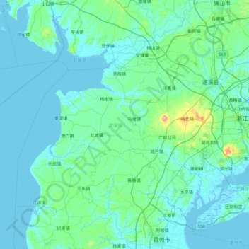
Name: 遂溪县 topographic map, elevation, terrain.
Location: 遂溪县, 湛江市, 广东省, 中国 (20.99549 109.63058 21.50966 110.41597)
Average elevation: 19 m
Minimum elevation: -3 m
Maximum elevation: 226 m
地势主要为丘陵和平原。其中东北部有低丘陵,其余三面地势平缓。陆地最高点为螺岗岭,海拔233米。
Other topographic maps
Click on a map to view its topography, its elevation and its terrain.