
Make a donation
Mizoram topographic map
Click on the map to display elevation.
Make a donation
Mizoram
Mizoram is a land of rolling hills, valleys, rivers and lakes. As many as 21 major hill ranges or peaks of different heights run through the length and breadth of the state, with plains scattered here and there. The average height of the hills to the west of the state is about 1,000 metres (3,300 ft). These gradually rise up to 1,300 metres (4,300 ft) to the east. Some areas, however, have higher ranges which go up to a height of over 2,000 metres (6,600 ft). Phawngpui Tlang also known as the Blue Mountain, situated in the southeastern part of the state, is the highest peak in Mizoram at 2,210 metres (7,250 ft). About 76% of the state is covered by forests, 8% is fallows land, 3% is barren and considered uncultivable area, while cultivable and sown area constitutes the rest. Slash-and-burn or jhum cultivation, though discouraged, remains in practice in Mizoram and affects its topography. A report by Ministry of Environment, Forest and Climate Change in 2021 states that Mizoram has the highest forest cover as a percentage of its geographical area of any Indian state, being 84.53% forest.
Make a donation
About this map
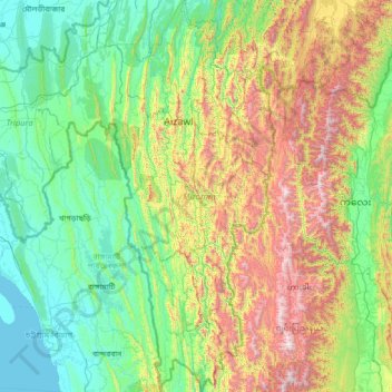
Name: Mizoram topographic map, elevation, terrain.
Location: Mizoram, India (21.94126 92.26022 24.52120 93.43737)
Average elevation: 544 m
Minimum elevation: 0 m
Maximum elevation: 2,637 m
Make a donation
Other topographic maps
Click on a map to view its topography, its elevation and its terrain.
Chandoli National Park
India > Maharashtra > Shirala
The park spreads along the crest of the Sahyadri Range of the northern Western Ghats. It forms and protects many perennial water channels, water holes and the Vasant Sagar Reservoir. Elevation of the park ranges from 589–1,044 m (1,932–3,425 ft). The park receives its water supply from the Warna river and…
Average elevation: 749 m
Make a donation
Chittoor
India > Andhra Pradesh > Chittoor
It is located between the northern latitudes of 37" and 14°8" and between the eastern longitudes 78°33" and 79°55". It is bounded on the east by Tirupati district of Andhra Pradesh, on the south by Krishnagiri District , Vellore, Tiruvallur,Thirupattur districts of Tamil Nadu, on the west by Kolar district…
Average elevation: 350 m
Make a donation
Varanasi
India > Uttar Pradesh > Sadar
Varanasi is located at an elevation of 80.71 metres (264.8 ft) in the centre of the Ganges valley of North India, in the Eastern part of the state of Uttar Pradesh, along the left crescent-shaped bank of the Ganges, averaging between 15 metres (50 ft) and 21 metres (70 ft) above the river. The city is the…
Average elevation: 77 m
Make a donation
Bagalkote
India > Karnataka > Bagalakote taluk
Bagalakote, is a city in the state of Karnataka, India, which is also the headquarters of Bagalakote district. It is situated on branch of River Ghataprabha about 481 km (299 mi) northwest of state capital Bengaluru, 410 km (255 mi) southwest of Hyderabad, and about 570 km (354 mi) southeast of Mumbai. The…
Average elevation: 556 m
Auroville
India > Tamil Nadu > Vanur
It is included in the sub-humid tropics (wet-and-dry tropical climate) situated on a plateau region with its maximum elevation of 32 m (105 ft) above sea level located in the Matrimandir area. The annual rainfall average is 1,200 mm (47 in) mainly from the SW monsoon (June to Sept.) and NE monsoon (Nov to Dec)…
Average elevation: 36 m
Make a donation
Sliding Rock
India > Andhra Pradesh > Kurabalakota > Mandemvaripalli > Sriramavaripalli
Average elevation: 740 m
Palanpur
India > Gujarat > Palanpur Taluka
Palanpur is located at 24°06′N 72°15′E / 24.10°N 72.25°E / 24.10; 72.25. It has an average elevation of 209 metres (685 ft).
Average elevation: 218 m
Make a donation
Badami
India > Karnataka > Badami taluku
Badami is located at 15°55′N 75°41′E / 15.92°N 75.68°E / 15.92; 75.68. It has an average elevation of 586 metres (1922 ft). It is located at the mouth of a ravine between two rocky hills and surrounds Agastya tirtha water reservoir on the three other sides. The total area of the town is 10.3…
Average elevation: 587 m
Make a donation
Bengaluru
India > Karnataka > Bangalore North > Bengaluru
Bangalore (/bæŋɡəˈlɔːr/), officially known as Bengaluru (Kannada pronunciation: (listen)), is the capital and the largest city of the Indian state of Karnataka. It has a population of more than 8 million and a metropolitan population of around 11 million, making it the third most populous city and fifth…
Average elevation: 879 m
Make a donation