
Mashonaland West Province topographic map
Interactive map
Click on the map to display elevation.
About this map
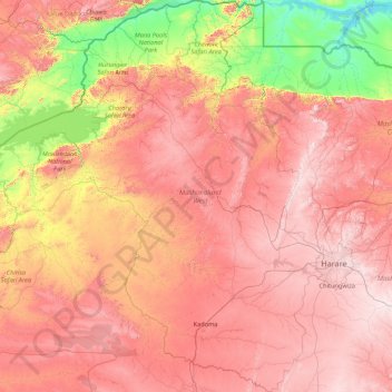
Name: Mashonaland West Province topographic map, elevation, terrain.
Location: Mashonaland West Province, Zimbabwe (-18.90539 28.03112 -15.60970 30.95849)
Average elevation: 971 m
Minimum elevation: 314 m
Maximum elevation: 1,724 m
Other topographic maps
Click on a map to view its topography, its elevation and its terrain.
Lake Chivero
Lake Chivero, Kamba Caravan Park Acces Road, Zvimba, Mashonaland West, Zimbabwe
Average elevation: 1,382 m
Hwange
Hwange, Matabeleland North, 00236, Zimbabwe
Average elevation: 968 m
Mount Nyangani
Mount Nyangani, Nyanga, Manicaland, Zimbabwe
Average elevation: 2,329 m