Geolocate

Khyber Pakhtunkhwa topographic map

Interactive map

Click on the map to display elevation.

Khyber Pakhtunkhwa

Most precipitation falls as thunderstorms or snow during winter and spring, so that the climate at the lowest elevations is classed as Mediterranean (Csa), continental Mediterranean (Dsa) or semi-arid (BSk). Summers are extremely dry in the north of Chitral district and receive only a little rain in the south around Drosh.

Wikipedia (CC-BY-SA 3.0)

About this map

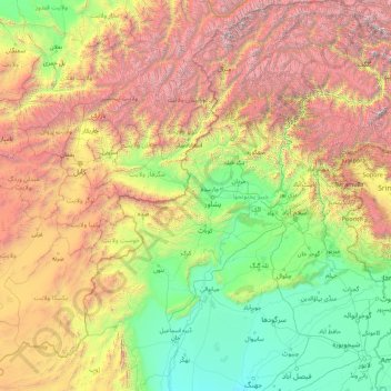
Name: Khyber Pakhtunkhwa topographic map, elevation, terrain.

Location: Khyber Pakhtunkhwa, Pakistan (31.06680 69.23780 36.90879 74.11646)

Average elevation: 1,902 m

Minimum elevation: 146 m

Maximum elevation: 7,597 m

Other topographic maps

Click on a map to view its topography, its elevation and its terrain.

Leti

Pakistan > Punjab > Talagang District

Average elevation: 394 m

Altit

Pakistan > Gilgit-Baltistan

Average elevation: 2,610 m

Kidney Hill Park

Pakistan > Sindh > Gulshan Town > Al Hamra

Average elevation: 34 m

Wadh

Pakistan > Balochistan

Average elevation: 1,262 m

Munda

Pakistan > Punjab > Munda

Average elevation: 137 m

Abbottabad

Pakistan > Khyber Pakhtunkhwa > Abbottabad

Average elevation: 1,365 m

Jamshed Town

Pakistan > Sindh > Karachi

Average elevation: 19 m

Hyderabad

Pakistan > Sindh > Hyderabad

Located at 25.367 °N latitude and 68.367 °E longitude with an elevation of 13 metres (43 ft), Hyderabad is located on the east bank of the Indus River and is roughly 150 kilometres (93 mi) away from Karachi, the provincial capital. Two of Pakistan's largest highways, the Indus Highway and the National…

Average elevation: 28 m

Multān District

Pakistan > Punjab

Average elevation: 129 m

Chakwal

Pakistan > Punjab > Chakwal

Average elevation: 523 m

Murree

Pakistan > Punjab > Murree

The sanatorium of Murree lies in north latitude 33° 54′ 30″ and east longitude 73° 26′ 30″, at an elevation of 7,517 feet (2,291 m) above sea level, and contained a standing population of 1,768 inhabitants, which was, however, enormously increased during the season by the influx of visitors and their…

Average elevation: 1,718 m

Raiwind

Pakistan > Punjab > Raiwind

Average elevation: 205 m

سوات

Pakistan > Khyber Pakhtunkhwa > سوات

Average elevation: 1,396 m

Shangla

Pakistan > Khyber Pakhtunkhwa

Average elevation: 2,317 m

Haripur

Pakistan > Khyber Pakhtunkhwa > Haripur

Average elevation: 692 m

Kaghan

Pakistan > Khyber Pakhtunkhwa > Kaghan

Average elevation: 2,464 m