
Murree topographic map
Interactive map
Click on the map to display elevation.
Murree
The sanatorium of Murree lies in north latitude 33° 54′ 30″ and east longitude 73° 26′ 30″, at an elevation of 7,517 feet (2,291 m) above sea level, and contained a standing population of 1,768 inhabitants, which was, however, enormously increased during the season by the influx of visitors and their attendant servants and shopkeepers. It is the most accessible hill station in the Punjab, being distant from Rawalpindi only a five hours' journey by tonga dak. Magnificent views are to be obtained in the spring and autumn of the snow crowned mountains of Kashmir; and gorgeous sunset and cloud effects seen daily during the rains . Part of the station, especially the Kashmir end, are also well wooded and pretty.
About this map
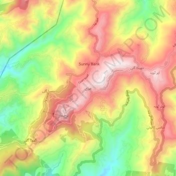
Name: Murree topographic map, elevation, terrain.
Location: Murree, Tehsil Murree, District Rawalpindi, Punjab, Pakistan (33.86568 73.35267 33.94568 73.43267)
Average elevation: 1,718 m
Minimum elevation: 1,162 m
Maximum elevation: 2,256 m