
月潭湖镇 topographic map
Interactive map
Click on the map to display elevation.
About this map
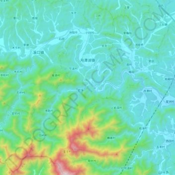
Name: 月潭湖镇 topographic map, elevation, terrain.
Location: 月潭湖镇, 休宁县, 黄山市, 安徽省, 中国 (29.55732 117.99679 29.74052 118.10398)
Average elevation: 346 m
Minimum elevation: 135 m
Maximum elevation: 1,437 m
Other topographic maps
Click on a map to view its topography, its elevation and its terrain.