
儒岙镇 topographic map
Interactive map
Click on the map to display elevation.
About this map
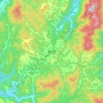
Name: 儒岙镇 topographic map, elevation, terrain.
Location: 儒岙镇, 绍兴市, 浙江省, 中国 (29.32520 120.88762 29.40520 120.96762)
Average elevation: 428 m
Minimum elevation: 161 m
Maximum elevation: 867 m
Other topographic maps
Click on a map to view its topography, its elevation and its terrain.