
岭北镇 topographic map
Interactive map
Click on the map to display elevation.
About this map
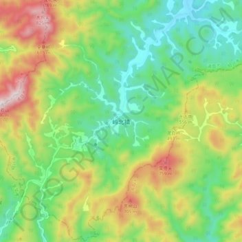
Name: 岭北镇 topographic map, elevation, terrain.
Location: 岭北镇, 绍兴市, 浙江省, 中国 (29.35680 120.26383 29.43680 120.34383)
Average elevation: 381 m
Minimum elevation: 94 m
Maximum elevation: 872 m
Other topographic maps
Click on a map to view its topography, its elevation and its terrain.