
蓬溪县 topographic map
Interactive map
Click on the map to display elevation.
About this map
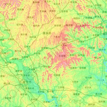
Name: 蓬溪县 topographic map, elevation, terrain.
Location: 蓬溪县, 遂宁市, 四川省, 中国 (30.37169 105.42792 30.93862 105.99758)
Average elevation: 349 m
Minimum elevation: 243 m
Maximum elevation: 567 m
全县地势东北、西北低,由被向南呈波壮起伏,北部平均海拔为485米,最高点为任隆镇白坡,顶峰海拔565.8米。南部平均海拔380米,最低点荷叶细坝,海拔251.3米。全县平均海拔为400米左右。地貌以丘陵为主,丘陵面积约占全县总面积的52.9%,沟谷面积占总面积的32%,平坝面积占13.5%,低山面积占1.5%。
Other topographic maps
Click on a map to view its topography, its elevation and its terrain.