
九寨沟县 topographic map
Interactive map
Click on the map to display elevation.
About this map
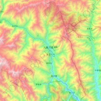
Name: 九寨沟县 topographic map, elevation, terrain.
Location: 九寨沟县, 阿坝藏族羌族自治州, 四川省, 623400, 中国 (33.09363 104.08118 33.41363 104.40118)
Average elevation: 2,520 m
Minimum elevation: 1,182 m
Maximum elevation: 4,352 m
九寨沟县(藏語:གཟི་རྩ་སྡེ་དགུ་རྫོང་།,威利转写:gzi-rtsa sde-dgu rdzong,藏语拼音:Sirza Degu Zong),是中国四川省阿坝藏族羌族自治州的辖县,位于阿坝的东北部,与甘肃省接壤,县人民政府驻南坪镇,县城海拔约1400米。
Other topographic maps
Click on a map to view its topography, its elevation and its terrain.