
Make a donation
Philadelphia topographic map
Click on the map to display elevation.
Make a donation
About this map
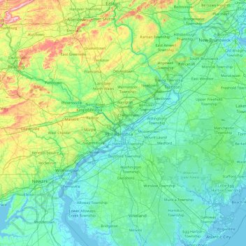
Name: Philadelphia topographic map, elevation, terrain.
Location: Philadelphia, Pennsylvania, 19140, United States (39.31145 -75.83265 40.71145 -74.43265)
Average elevation: 68 m
Minimum elevation: -4 m
Maximum elevation: 496 m
Make a donation
Other topographic maps
Click on a map to view its topography, its elevation and its terrain.
Make a donation
Make a donation
Make a donation
Lake Ontelaunee Dam
United States > Pennsylvania > Berks County > Ontelaunee Township
Average elevation: 99 m
North Coventry Township
United States > Pennsylvania > Chester County > North Coventry Township
Average elevation: 108 m
Make a donation
Raystown Lake
United States > Pennsylvania > Huntingdon County > Lincoln Township
The proposal for the new dam incorporated the ideas of bringing tourism into the area, promoting recreation, and flood control. The actual purpose stated, "The project will provide flood control, recreation, water quality and fish and wildlife enhancement" (U.S. Army Corps of Engineers, 1974). Although tourism…
Average elevation: 380 m
Make a donation
Make a donation
Make a donation
Make a donation
Shanor-Northvue
United States > Pennsylvania > Butler County > Windward Heights
Average elevation: 378 m
Make a donation
Susquehanna Trails
United States > Pennsylvania > York County > Peach Bottom Township
Average elevation: 141 m
Make a donation
Make a donation
Brackenridge
United States > Pennsylvania > Allegheny County
Brackenridge is located at 40°36′30″N 79°44′32″W / 40.60833°N 79.74222°W / 40.60833; -79.74222. The borough's average elevation is 827 feet (252 m) above sea level. According to the U.S. Census Bureau, the borough has a total area of 0.6 square miles (1.6 km2), of which 0.5 square miles…
Average elevation: 266 m
Temple
United States > Pennsylvania > Berks County > Muhlenberg Township
Temple is a census-designated place in Muhlenberg Township, Berks County, Pennsylvania, United States at an elevation of 361 feet (110 m). The community was named for a local inn called Solomon's Temple. Temple was an independent borough until it was disincorporated on January 1, 1999. The ZIP code is 19560.…
Average elevation: 126 m
Make a donation
Village Green-Green Ridge
United States > Pennsylvania > Delaware County > Aston Township
Average elevation: 48 m
Linntown
United States > Pennsylvania > Union County > East Buffalo Township > Linntown
Average elevation: 152 m
Make a donation
Georges Township
United States > Pennsylvania > Fayette County
Georges Township is in southwestern Fayette County. It surrounds the boroughs of Fairchance (near the center of the township) and Smithfield (in the southwest). Pennsylvania Route 43 (the Mon–Fayette Expressway), U.S. Route 119, and Pennsylvania Route 857 cross the township, running roughly parallel. All…
Average elevation: 506 m
Make a donation
Make a donation
Make a donation
Make a donation
Shenandoah Heights
United States > Pennsylvania > Schuylkill County > West Mahanoy Township
Average elevation: 470 m
Make a donation
Make a donation
Make a donation
Make a donation
Russellton
United States > Pennsylvania > Allegheny County > West Deer Township
Average elevation: 325 m
Make a donation
Curtisville
United States > Pennsylvania > Allegheny County > West Deer Township > Curtisville
Average elevation: 344 m
Make a donation
Make a donation
Make a donation