
Thank you for supporting this site ❤️
Make a donation
Make a donation
Trevorton topographic map
Click on the map to display elevation.
Thank you for supporting this site ❤️
Make a donation
Make a donation
About this map
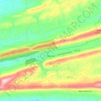
Name: Trevorton topographic map, elevation, terrain.
Average elevation: 304 m
Minimum elevation: 164 m
Maximum elevation: 517 m
Thank you for supporting this site ❤️
Make a donation
Make a donation
Other topographic maps
Click on a map to view its topography, its elevation and its terrain.
Overlook
United States > Pennsylvania > Northumberland County > Ralpho Township
Average elevation: 261 m
Bear Gap
United States > Pennsylvania > Northumberland County > Ralpho Township > Bear Gap
Average elevation: 317 m
Fishers Ferry
United States > Pennsylvania > Northumberland County > Fishers Ferry
Average elevation: 168 m
Thank you for supporting this site ❤️
Make a donation
Make a donation
Thank you for supporting this site ❤️
Make a donation
Make a donation