
Make a donation
Sayre topographic map
Click on the map to display elevation.
Make a donation
About this map
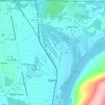
Name: Sayre topographic map, elevation, terrain.
Location: Sayre, Bradford County, Pennsylvania, 18840, United States (41.97247 -76.53696 41.99983 -76.50455)
Average elevation: 251 m
Minimum elevation: 227 m
Maximum elevation: 409 m
Make a donation
Other topographic maps
Click on a map to view its topography, its elevation and its terrain.
East Smithfield
United States > Pennsylvania > Bradford County > Smithfield Township
Average elevation: 416 m
Lake Wesauking
United States > Pennsylvania > Bradford County > Wysox Township
Average elevation: 355 m
Windham Summit
United States > Pennsylvania > Bradford County > Windham Township
Average elevation: 430 m
Make a donation
Columbia Cross Roads
United States > Pennsylvania > Bradford County > Columbia Township
Average elevation: 411 m
Make a donation
Gillett
United States > Pennsylvania > Bradford County > South Creek Township
Average elevation: 470 m
Granville Summit
United States > Pennsylvania > Bradford County > Granville Township
Average elevation: 448 m
Make a donation
Sheshequin
United States > Pennsylvania > Bradford County > Sheshequin Township
Average elevation: 310 m
Stevensville
United States > Pennsylvania > Bradford County > Stevens Township
Average elevation: 328 m
Warren Center
United States > Pennsylvania > Bradford County > Warren Township
Average elevation: 474 m
Make a donation
Make a donation
Make a donation