
Thank you for supporting this site ❤️
Make a donation
Make a donation
Duncansville topographic map
Click on the map to display elevation.
Thank you for supporting this site ❤️
Make a donation
Make a donation
About this map
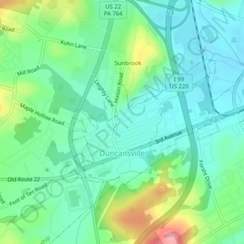
Name: Duncansville topographic map, elevation, terrain.
Location: Duncansville, Blair County, Pennsylvania, United States (40.41986 -78.44148 40.43374 -78.41979)
Average elevation: 331 m
Minimum elevation: 296 m
Maximum elevation: 420 m
Thank you for supporting this site ❤️
Make a donation
Make a donation
Other topographic maps
Click on a map to view its topography, its elevation and its terrain.
Yellow Spring
United States > Pennsylvania > Blair County > Catharine Township
Average elevation: 358 m
Thank you for supporting this site ❤️
Make a donation
Make a donation