Geolocate

汤溪镇 topographic map

Interactive map

Click on the map to display elevation.

About this map

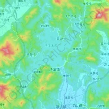
Name: 汤溪镇 topographic map, elevation, terrain.

Location: 汤溪镇, 饶平县, 潮州市, 广东省, 515733, 中国 (23.85704 116.78170 23.97142 116.91742)

Average elevation: 130 m

Minimum elevation: 16 m

Maximum elevation: 675 m

Other topographic maps

Click on a map to view its topography, its elevation and its terrain.

细格栅及旋流沉砂池

中国 > 广东省 > 饶平县 > 柘林镇

细格栅及旋流沉砂池, 柘林镇, 饶平县, 潮州市, 广东省, 中国

Average elevation: 8 m

Xi’ao Dao

中国 > 广东省 > 饶平县 > 柘林镇

Xi’ao Dao, 柘林镇, 饶平县, 潮州市, 广东省, 中国

Average elevation: 8 m

盐糟寨

中国 > 广东省 > 饶平县 > 黄冈镇

盐糟寨, 黄冈镇, 饶平县, 潮州市, 广东省, 中国

Average elevation: 16 m

娘仔坟

中国 > 广东省 > 饶平县 > 黄冈镇

娘仔坟, 黄冈镇, 饶平县, 潮州市, 广东省, 515700, 中国

Average elevation: 30 m

龙船顶

中国 > 广东省 > 饶平县 > 黄冈镇

龙船顶, 黄冈镇, 饶平县, 潮州市, 广东省, 515700, 中国

Average elevation: 34 m

上林公园

中国 > 广东省 > 饶平县 > 黄冈镇

上林公园, 教师村, 黄冈镇, 饶平县, 潮州市, 广东省, 中国

Average elevation: 22 m

滤池

中国 > 广东省 > 饶平县 > 黄冈镇

滤池, 黄冈镇, 饶平县, 潮州市, 广东省, 中国

Average elevation: 24 m

黄冈镇

中国 > 广东省 > 饶平县

黄冈镇, 饶平县, 潮州市, 广东省, 515700, 中国

Average elevation: 21 m