
禾甸镇 topographic map
Interactive map
Click on the map to display elevation.
About this map
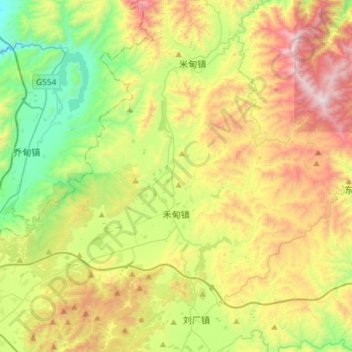
Name: 禾甸镇 topographic map, elevation, terrain.
Location: 禾甸镇, 祥云县, 大理白族自治州, 云南省, 中国 (25.46991 100.61246 25.73202 100.90479)
Average elevation: 2,052 m
Minimum elevation: 1,531 m
Maximum elevation: 2,845 m
Other topographic maps
Click on a map to view its topography, its elevation and its terrain.