
San Jacinto topographic map
Interactive map
Click on the map to display elevation.
About this map
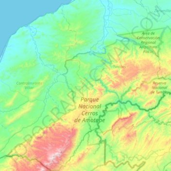
Name: San Jacinto topographic map, elevation, terrain.
Location: San Jacinto, Tumbes, Perú (-4.23190 -80.66645 -3.62292 -80.39803)
Average elevation: 354 m
Minimum elevation: 0 m
Maximum elevation: 1,584 m
Other topographic maps
Click on a map to view its topography, its elevation and its terrain.
Pampas de Hospital
Perú > Tumbes > Pampas de Hospital
Pampas de Hospital, Tumbes, Perú
Average elevation: 31 m
Parque Nacional Cerros de Amotape
Parque Nacional Cerros de Amotape, Tumbes, Perú
Average elevation: 413 m
Cancas
Perú > Tumbes > Canoas de Punta Sal > Cancas
Cancas, Canoas de Punta Sal, Provincia de Contralmirante Villar, Tumbes, Perú
Average elevation: 25 m
Reserva Nacional de Tumbes
Reserva Nacional de Tumbes, Provincia de Tumbes, Tumbes, Perú
Average elevation: 559 m
Río Tumbes
Perú > Tumbes > Pampas de Hospital
Río Tumbes, Pampas de Hospital, Provincia de Tumbes, Tumbes, Perú
Average elevation: 524 m