
Schwedenschanze topographic map
Interactive map
Click on the map to display elevation.
About this map
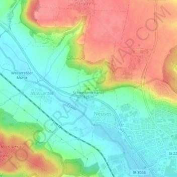
Name: Schwedenschanze topographic map, elevation, terrain.
Location: Schwedenschanze, Ansbach, Bayern, 91522, Deutschland (49.31856 10.54989 49.31866 10.54999)
Average elevation: 437 m
Minimum elevation: 401 m
Maximum elevation: 484 m
Other topographic maps
Click on a map to view its topography, its elevation and its terrain.
Bernhardswinden
Deutschland > Bayern > Ansbach
Bernhardswinden, Ansbach, Bayern, 91522, Deutschland
Average elevation: 471 m
Strüth
Deutschland > Bayern > Ansbach
Strüth, Ansbach, Bayern, 91522, Deutschland
Average elevation: 451 m
Katterbach
Deutschland > Bayern > Ansbach
Katterbach, Ansbach, Bayern, 91623, Deutschland
Average elevation: 452 m
Brodswinden
Deutschland > Bayern > Ansbach > Brodswinden
Brodswinden, Ansbach, Bayern, 91595, Deutschland
Average elevation: 457 m