
Monduli topographic map
Interactive map
Click on the map to display elevation.
About this map
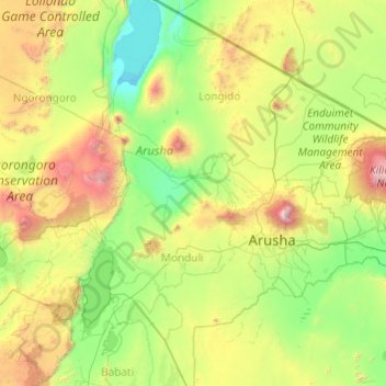
Name: Monduli topographic map, elevation, terrain.
Location: Monduli, Arusha, Northern Zone, Tanzanie (-4.09931 35.87043 -2.16582 37.40665)
Average elevation: 1,370 m
Minimum elevation: 594 m
Maximum elevation: 4,451 m
Other topographic maps
Click on a map to view its topography, its elevation and its terrain.
Lac Natron
Lac Natron, Ngorongoro, Arusha, Northern Zone, Tanzanie
Average elevation: 861 m
Mt Kitumbeine
Mt Kitumbeine, Monduli, Arusha, Northern Zone, Tanzanie
Average elevation: 2,694 m
Mount Meru
Mount Meru, Arumeru, Arusha, Northern Zone, Tanzanie
Average elevation: 3,884 m