
Karatu topographic map
Interactive map
Click on the map to display elevation.
About this map
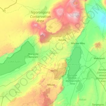
Name: Karatu topographic map, elevation, terrain.
Location: Karatu, Arusha, Northern Zone, 23601, Tanzanie (-3.89561 34.77088 -3.17368 35.95713)
Average elevation: 1,501 m
Minimum elevation: 786 m
Maximum elevation: 3,625 m
Other topographic maps
Click on a map to view its topography, its elevation and its terrain.
Lac Natron
Lac Natron, Ngorongoro, Arusha, Northern Zone, Tanzanie
Average elevation: 861 m
Mt Kitumbeine
Mt Kitumbeine, Monduli, Arusha, Northern Zone, Tanzanie
Average elevation: 2,694 m
Mount Meru
Mount Meru, Arumeru, Arusha, Northern Zone, Tanzanie
Average elevation: 3,884 m