
高邑县 topographic map
Interactive map
Click on the map to display elevation.
About this map
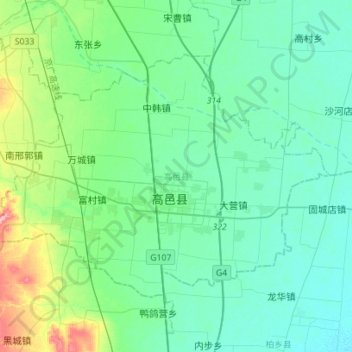
Name: 高邑县 topographic map, elevation, terrain.
Location: 高邑县, 石家庄市, 河北省, 中国 (37.54324 114.45073 37.69645 114.73024)
Average elevation: 55 m
Minimum elevation: 32 m
Maximum elevation: 154 m
Other topographic maps
Click on a map to view its topography, its elevation and its terrain.