
玉龙雪山 topographic map
Interactive map
Click on the map to display elevation.
About this map
Name: 玉龙雪山 topographic map, elevation, terrain.
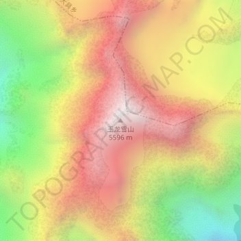
Location: 玉龙雪山, 丽江市, 云南省, 中国 (27.09836 100.17665 27.09846 100.17675)
Average elevation: 4,829 m
Minimum elevation: 3,928 m
Maximum elevation: 5,568 m
玉龍雪山(东巴文:)是雲南省麗江市玉龍納西族自治縣的一个南北向山脉,位于橫斷山脉的沙魯裏山南段,海拔5596m。雪山山腰雲騰霧繞,遠望像一條銀白色的巨龍,因此得名。為納西族的神山和聚居地之一;納西族人稱雪山爲“歐魯”,意爲“銀色的山岩”。雪山南北長35公里,東西寬13公里,主峰扇子陡海拔5596米。是中华人民共和国乃至欧亚大陆现今最南端的终年积雪雪山。
Other topographic maps
Click on a map to view its topography, its elevation and its terrain.