
Hainan Province topographic map
Interactive map
Click on the map to display elevation.
About this map
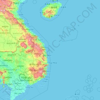
Name: Hainan Province topographic map, elevation, terrain.
Location: Hainan Province, China (8.66504 108.38823 20.34391 118.04440)
Average elevation: 95 m
Minimum elevation: -3 m
Maximum elevation: 2,518 m
Even while Hainan Island was a part of Guangdong it had a considerable amount of local autonomy; the southern half of the island was an autonomous prefecture. Hainan's elevation to provincial level in 1988 increased its accountability to the Central People's Government, but by designating the new province a special economic zone the central government expressed its intent to allow Hainan maximum flexibility in devising programs to facilitate foreign investment and economic growth. Administratively, the province has been divided into five economic major districts.
Other topographic maps
Click on a map to view its topography, its elevation and its terrain.
桥下村
China > Jiangxi > Jing'an County > Luowan
桥下村, Luowan, Jing'an County, Yichun, Jiangxi, China
Average elevation: 492 m
Guanzhuang
China > Hunan > Yuanling County
Guanzhuang, Yuanling County, Huaihua, Hunan, China
Average elevation: 385 m
Chengguan District
Chengguan District, Lhasa, Tibet, 850000, China
Average elevation: 4,325 m
Longde
China > Ningxia > Longde County
Longde, Longde County, Guyuan City, Ningxia, China
Average elevation: 2,158 m
Guangzhou City
Guangzhou City, Guangdong Province, China
Average elevation: 98 m
Kidney Hill
China > Hong Kong > North District
Kidney Hill, North District, New Territories, Hong Kong, 518032, China
Average elevation: 27 m
Anping County
Anping County, Hengshui, Hebei, 053600, China
Average elevation: 28 m
Yancheng City
China > Jiangsu > Yancheng City
Yancheng City, Jiangsu, 224043, China
Average elevation: 3 m
Dongguan
China > Guangdong Province > Dongguan
Dongguan, Guangdong Province, 523058, China
Average elevation: 20 m
Changzhou
China > Jiangsu > Xinbei District > Changzhou
Changzhou, Xinbei District, Changzhou, Jiangsu, 213000, China
Average elevation: 6 m
Huainan City
China > Anhui > Tianjia'an District > Huainan City
Huainan City, Tianjia'an District, Anhui, China
Average elevation: 40 m
Yantai City
China > Shandong > Yantai City
Yantai City, Shandong, 264000, China
Average elevation: 39 m
Shaxi
China > Guangdong Province > Zhongshan > Shaxi > Shenmingtingcun
Shaxi, Zhongshan, Shenmingtingcun, Guangdong Province, China
Average elevation: 8 m
Hangcheng Sub-district
China > Guangdong Province > Bao'an District > Hangcheng Sub-district
Hangcheng Sub-district, Bao'an District, Shenzhen, Guangdong Province, 518100, China
Average elevation: 21 m
Xinghua City
China > Jiangsu > Xinghua City
Xinghua City, Taizhou, Jiangsu, 225700, China
Average elevation: 3 m
Fuzhou
China > Jiangxi > Fuzhou > Zhongling Subdistrict
Fuzhou, Zhongling Subdistrict, 金巢开发区, Linchuan District, Fuzhou City, Jiangxi, China
Average elevation: 54 m
Kashgar City
China > Xinjiang > Kashgar City
Kashgar, Kashgar City, Kashgar Prefecture, Xinjiang, 844000, China
Average elevation: 1,355 m
North District
North District, New Territories, Hong Kong, China
Average elevation: 115 m
Dongcheng District
China > Beijing > Dongcheng District
Beijing, Dongcheng District, Beijing, 100010, China
Average elevation: 497 m