Geolocate

Liaoning topographic map

Interactive map

Click on the map to display elevation.

About this map

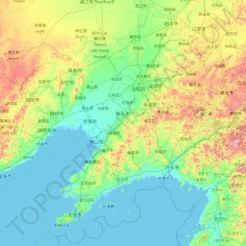
Name: Liaoning topographic map, elevation, terrain.

Location: Liaoning, China (38.37191 118.83988 43.48889 125.78521)

Average elevation: 208 m

Minimum elevation: -2 m

Maximum elevation: 1,770 m

Other topographic maps

Click on a map to view its topography, its elevation and its terrain.

Zhejiang

China

Zhejiang consists mostly of hills, which account for about 70% of its total area, with higher altitudes towards the south and the west. Zhejiang also has a longer coastline than any other mainland province of China. The Qiantang River runs through the province, from which it derives its name. Included in the…

Average elevation: 223 m

Changmai

China > Sichuan > Baiyü County

Average elevation: 4,248 m

桥下村

China > Jiangxi > Jing'an County > Luowan

Average elevation: 492 m

Guanzhuang

China > Hunan > Yuanling County

Average elevation: 385 m

Hainan Province

China

Even while Hainan Island was a part of Guangdong it had a considerable amount of local autonomy; the southern half of the island was an autonomous prefecture. Hainan's elevation to provincial level in 1988 increased its accountability to the Central People's Government, but by designating the new province a…

Average elevation: 95 m

Inner Mongolia

China

Inner Mongolia largely consists of the northern side of the North China Craton, a tilted and sedimented Precambrian block. In the extreme southwest is the edge of the Tibetan Plateau where the autonomous region's highest peak, Main Peak in the Helan Mountains reaches 3,556 metres (11,670 ft), and is still…

Average elevation: 891 m

Beilin District

China > Shaanxi

Average elevation: 414 m

Chengguan District

China > Tibet

Lhasa is the second most populous urban area on the Tibetan Plateau after Xining and, at an altitude of 3,656 metres (11,990 ft), Lhasa is one of the highest cities in the world. The city has been the religious and administrative capital of Tibet since the mid-17th century. It contains many culturally…

Average elevation: 4,325 m

Tianjin

China

There is 153 km (95 mi) of coastline and 1,137.48 kilometers (706.80 mi) of land border. It lies at the northern end of the Grand Canal of China, which connects with the Yellow River and Yangtze River. The municipality is generally flat, and swampy near the coast, but hilly in the far north, where the Yan…

Average elevation: 64 m

Panzhihua

China > Sichuan

Average elevation: 1,994 m

Longde

China > Ningxia > Longde County

Average elevation: 2,158 m

Guangzhou City

China > Guangdong Province

The elevation of the prefecture generally increases from southwest to northeast, with mountains forming the backbone of the city and the ocean comprising the front. Tiantang Peak (simplified Chinese: 天堂顶; traditional Chinese: 天堂頂, "Heavenly Peak") is the highest point of elevation at 1,210 m (3,970…

Average elevation: 98 m

Kidney Hill

China > Hong Kong > North District

Average elevation: 27 m

Anping County

China > Hebei > Hengshui

Average elevation: 28 m

Hongshan District

China > Hubei

Average elevation: 27 m

Municipality of Macau

China > Macau

Average elevation: 14 m

Yancheng City

China > Jiangsu > Yancheng City

Average elevation: 3 m

Tashbulaq

China > Xinjiang > Hami > Tashbulaq

Average elevation: 1,408 m

Lhasa

China > Tibet

Lhasa has an elevation of about 3,600 m (11,800 ft) and lies in the centre of the Tibetan Plateau with the surrounding mountains rising to 5,500 m (18,000 ft). The air only contains 68 percent of the oxygen compared to sea level. The Lhasa River, also Kyi River or Kyi Chu, a tributary of the Yarlung Zangbo…

Average elevation: 4,868 m

Zibo City

China > Shandong > Zibo City

Average elevation: 190 m

Changzhou

China > Jiangsu > Xinbei District > Changzhou

Average elevation: 6 m

Dongguan

China > Guangdong Province > Dongguan

Average elevation: 20 m

Huainan City

China > Anhui > Tianjia'an District > Huainan City

Average elevation: 40 m

Shaxi

China > Guangdong Province > Zhongshan > Shaxi > Shenmingtingcun

Average elevation: 8 m

Yantai City

China > Shandong > Yantai City

Yantai is located along the north coast of the Shandong Peninsula, south of the junction of Bohai Sea and Yellow Sea and parallel to the southern coast of Liaoning. The topographical breakdown consists of.

Average elevation: 39 m

Nanping City

China > Fujian > Nanping City

Average elevation: 525 m

Quanzhou

China > Fujian > Quanzhou

Average elevation: 34 m

Hong Kong Island

China > Hong Kong

Average elevation: 36 m

Xinghua City

China > Jiangsu > Xinghua City

Average elevation: 3 m

Hubei

China

Average elevation: 363 m

Wuxi City

China > Jiangsu > Wuxi City

Average elevation: 8 m

Jiaxing

China > Zhejiang > Jiaxing

Average elevation: 5 m

Chini

China > Guangxi > Guigang > Chini

Average elevation: 36 m

Dingxi

China > Gansu > Dingxi

Average elevation: 2,042 m

Fuzhou

China > Jiangxi > Fuzhou > Zhongling Subdistrict

Average elevation: 54 m

Yangzhou City

China > Jiangsu > Yangzhou City

Average elevation: 10 m

Zhengzhou

China > Henan > Zhengzhou

Average elevation: 162 m

New Territories

China > Hong Kong

Average elevation: 44 m

Shanghai

China

The golden age of Shanghai began with its elevation to municipality on 7 July 1927. This new Chinese municipality covered an area of 494.69 km2 (191.0 sq mi), including the modern-day districts of Baoshan, Yangpu, Zhabei, Nanshi, and Pudong, but excluded the foreign concessions territories. Headed by a Chinese…

Average elevation: 38 m

Kowloon

China > Hong Kong

Average elevation: 93 m

Nanning City

China > Guangxi

Average elevation: 229 m

Kashgar City

China > Xinjiang > Kashgar City

Average elevation: 1,355 m

Bengbu

China > Anhui > Bengbu

Average elevation: 29 m

North District

China > Hong Kong

Average elevation: 115 m

Hefei City

China > Anhui

Average elevation: 66 m

Dongcheng District

China > Beijing > Dongcheng District

Beijing is situated at the northern tip of the roughly triangular North China Plain, which opens to the south and east of the city. Mountains to the north, northwest and west shield the city and northern China's agricultural heartland from the encroaching desert steppes. The northwestern part of the…

Average elevation: 497 m

Xiangtan

China > Xiangtan

Average elevation: 64 m

Suzhou City

China > Jiangsu

Average elevation: 5 m

Hangzhou City

China > Zhejiang

Average elevation: 186 m