Geolocate

Islamabad Capital Territory topographic map

Interactive map

Click on the map to display elevation.

About this map

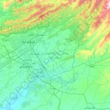
Name: Islamabad Capital Territory topographic map, elevation, terrain.

Location: Islamabad Capital Territory, Pakistan (33.46810 72.81760 33.80328 73.37488)

Average elevation: 697 m

Minimum elevation: 381 m

Maximum elevation: 2,190 m

Other topographic maps

Click on a map to view its topography, its elevation and its terrain.

Khyber Pakhtunkhwa

Pakistan

Most precipitation falls as thunderstorms or snow during winter and spring, so that the climate at the lowest elevations is classed as Mediterranean (Csa), continental Mediterranean (Dsa) or semi-arid (BSk). Summers are extremely dry in the north of Chitral district and receive only a little rain in the south…

Average elevation: 1,902 m

Altit

Pakistan > Gilgit-Baltistan

Average elevation: 2,610 m

Kidney Hill Park

Pakistan > Sindh > Gulshan Town > Al Hamra

Average elevation: 34 m

Wadh

Pakistan > Balochistan

Average elevation: 1,262 m

Munda

Pakistan > Punjab > Munda

Average elevation: 137 m

Abbottabad

Pakistan > Khyber Pakhtunkhwa > Abbottabad

Average elevation: 1,365 m

Kaghan

Pakistan > Khyber Pakhtunkhwa > Kaghan

Average elevation: 2,464 m

Haripur

Pakistan > Khyber Pakhtunkhwa > Haripur

Average elevation: 692 m

Shangla

Pakistan > Khyber Pakhtunkhwa

Average elevation: 2,317 m

سوات

Pakistan > Khyber Pakhtunkhwa > سوات

Average elevation: 1,396 m

Raiwind

Pakistan > Punjab > Raiwind

Average elevation: 205 m

Murree

Pakistan > Punjab > Murree

The sanatorium of Murree lies in north latitude 33° 54′ 30″ and east longitude 73° 26′ 30″, at an elevation of 7,517 feet (2,291 m) above sea level, and contained a standing population of 1,768 inhabitants, which was, however, enormously increased during the season by the influx of visitors and their…

Average elevation: 1,718 m

Chakwal

Pakistan > Punjab > Chakwal

Average elevation: 523 m

Multān District

Pakistan > Punjab

Average elevation: 129 m

Karachi Division

Pakistan > Sindh

Average elevation: 89 m

Hyderabad

Pakistan > Sindh > Hyderabad

Located at 25.367 °N latitude and 68.367 °E longitude with an elevation of 13 metres (43 ft), Hyderabad is located on the east bank of the Indus River and is roughly 150 kilometres (93 mi) away from Karachi, the provincial capital. Two of Pakistan's largest highways, the Indus Highway and the National…

Average elevation: 28 m

Jamshed Town

Pakistan > Sindh > Karachi

Average elevation: 19 m

Sindh

Pakistan

According to some accounts, there is no evidence of large palaces or burial grounds for the elite. The grand and presumably holy site might have been the great bath, which is built upon an artificially created elevation. This civilization collapsed around 1700 BC for reasons uncertain; the cause is hotly…

Average elevation: 173 m

Muztagh Tower

Pakistan > Gilgit-Baltistan

Average elevation: 5,972 m

Haramosh

Pakistan > Gilgit-Baltistan

Average elevation: 6,476 m

Indus River

Pakistan > Sindh > Sukkur

Average elevation: 64 m

Karāchi District

Pakistan > Sindh

Average elevation: 107 m

Saltoro Kangri

Pakistan > Gilgit-Baltistan

Average elevation: 6,652 m

Nanga Parbat

Pakistan > Gilgit-Baltistan

Average elevation: 7,086 m

Saraghrar I

Pakistan > Khyber Pakhtunkhwa

Average elevation: 6,780 m

Baltoro Glacier

Pakistan > Gilgit-Baltistan

Average elevation: 5,349 m

Batura Glacier

Pakistan > Gilgit-Baltistan

Average elevation: 4,775 m

Sangemarmur

Pakistan > Gilgit-Baltistan

Average elevation: 5,955 m

Rakaposhi

Pakistan > Gilgit-Baltistan > Gilgit

Average elevation: 6,882 m

Masherbrum

Pakistan > Gilgit-Baltistan

Average elevation: 6,469 m

Gasherbrum V

Pakistan > Gilgit-Baltistan

Average elevation: 6,267 m

Gasherbrum III

Pakistan > Gilgit-Baltistan

Average elevation: 7,082 m

Gasherbrum IV

Pakistan > Gilgit-Baltistan

Average elevation: 6,806 m

Trango Glacier

Pakistan > Gilgit-Baltistan

Average elevation: 5,284 m

Gasherbrum I

Pakistan > Gilgit-Baltistan

Average elevation: 7,177 m

Diran

Pakistan > Gilgit-Baltistan > Gilgit

Average elevation: 6,311 m