
Arley topographic map
Interactive map
Click on the map to display elevation.
About this map
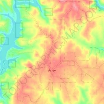
Name: Arley topographic map, elevation, terrain.
Location: Arley, Winston County, Alabama, United States (34.06398 -87.23143 34.11431 -87.18610)
Average elevation: 209 m
Minimum elevation: 151 m
Maximum elevation: 255 m
Other topographic maps
Click on a map to view its topography, its elevation and its terrain.
Lewis Smith Lake
United States > Alabama > Winston County
Lewis Smith Lake, Winston County, Alabama, United States
Average elevation: 208 m
Haleyville
United States > Alabama > Winston County
Haleyville, Winston County, Alabama, 35565, United States
Average elevation: 261 m
William B. Bankhead National Forest
United States > Alabama > Winston County
William B. Bankhead National Forest, Winston County, Alabama, United States
Average elevation: 232 m
Wilson Bend
United States > Alabama > Winston County > Wilson Bend
Wilson Bend, Winston County, Alabama, United States
Average elevation: 175 m
Double Springs
United States > Alabama > Winston County
Double Springs, Winston County, Alabama, 35553, United States
Average elevation: 226 m
Natural Bridge
United States > Alabama > Winston County
Natural Bridge, Winston County, Alabama, 35577, United States
Average elevation: 219 m