Geolocate

Haleyville topographic map

Interactive map

Click on the map to display elevation.

About this map

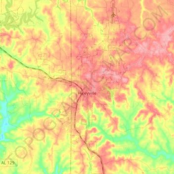
Name: Haleyville topographic map, elevation, terrain.

Location: Haleyville, Winston County, Alabama, 35565, United States (34.17185 -87.66156 34.28911 -87.58704)

Average elevation: 261 m

Minimum elevation: 195 m

Maximum elevation: 309 m

Other topographic maps

Click on a map to view its topography, its elevation and its terrain.

Lewis Smith Lake

United States > Alabama > Winston County

Lewis Smith Lake, Winston County, Alabama, United States

Average elevation: 208 m

William B. Bankhead National Forest

United States > Alabama > Winston County

William B. Bankhead National Forest, Winston County, Alabama, United States

Average elevation: 232 m

Wilson Bend

United States > Alabama > Winston County > Wilson Bend

Wilson Bend, Winston County, Alabama, United States

Average elevation: 175 m

Arley

United States > Alabama > Winston County

Arley, Winston County, Alabama, United States

Average elevation: 209 m

Natural Bridge

United States > Alabama > Winston County

Natural Bridge, Winston County, Alabama, 35577, United States

Average elevation: 219 m

Double Springs

United States > Alabama > Winston County

Double Springs, Winston County, Alabama, 35553, United States

Average elevation: 226 m