Lewis Smith Lake topographic map
Interactive map
Click on the map to display elevation.
About this map
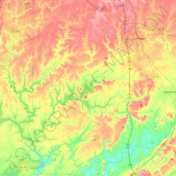
Name: Lewis Smith Lake topographic map, elevation, terrain.
Location: Lewis Smith Lake, Winston County, Alabama, United States (33.94207 -87.35736 34.19799 -86.91052)
Average elevation: 208 m
Minimum elevation: 82 m
Maximum elevation: 349 m
Other topographic maps
Click on a map to view its topography, its elevation and its terrain.
Haleyville
United States > Alabama > Winston County
Haleyville, Winston County, Alabama, 35565, United States
Average elevation: 261 m
William B. Bankhead National Forest
United States > Alabama > Winston County
William B. Bankhead National Forest, Winston County, Alabama, United States
Average elevation: 232 m
Wilson Bend
United States > Alabama > Winston County > Wilson Bend
Wilson Bend, Winston County, Alabama, United States
Average elevation: 175 m
Arley
United States > Alabama > Winston County
Arley, Winston County, Alabama, United States
Average elevation: 209 m
Natural Bridge
United States > Alabama > Winston County
Natural Bridge, Winston County, Alabama, 35577, United States
Average elevation: 219 m
Double Springs
United States > Alabama > Winston County
Double Springs, Winston County, Alabama, 35553, United States
Average elevation: 226 m