
Guadeloupe topographic map
Interactive map
Click on the map to display elevation.
About this map
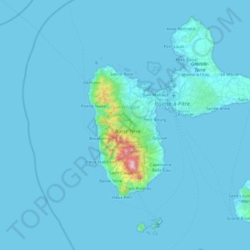
Name: Guadeloupe topographic map, elevation, terrain.
Location: Guadeloupe, France (15.83198 -61.80976 16.51448 -61.00130)
Average elevation: 37 m
Minimum elevation: -1 m
Maximum elevation: 1,442 m
The two main islands are Basse-Terre (west) and Grande-Terre (east), which form a butterfly shape as viewed from above, the two 'wings' of which are separated by the Grand Cul-de-Sac Marin, Rivière Salée [fr] and Petit Cul-de-Sac Marin. More than half of Guadeloupe's land surface consists of the 847.8 km2 Basse-Terre. The island is mountainous, containing such peaks as Mount Sans Toucher (4,442 feet; 1,354 metres) and Grande Découverte (4,143 feet; 1,263 metres), culminating in the active volcano La Grande Soufrière, the highest mountain peak in the Lesser Antilles with an elevation of 1,467 metres (4,813 ft). In contrast Grande-Terre is mostly flat, with rocky coasts to the north, irregular hills at the centre, mangrove at the southwest, and white sand beaches sheltered by coral reefs along the southern shore. This is where the main tourist resorts are found.
Other topographic maps
Click on a map to view its topography, its elevation and its terrain.
19250
France > Nouvelle-Aquitaine > Corrèze > Ambrugeat > Le Montbazet
19250, Le Montbazet, Ambrugeat, Ussel, Corrèze, Nouvelle-Aquitaine, Metropolitan France, France
Average elevation: 681 m
Gap
France > Provence-Alpes-Côte d'Azur > Hautes-Alpes
Gap, Hautes-Alpes, Provence-Alpes-Côte d'Azur, Metropolitan France, 05000, France
Average elevation: 1,146 m
Herm
France > Nouvelle-Aquitaine > Landes
Herm, District of Dax, Landes, Nouvelle-Aquitaine, Metropolitan France, 40990, France
Average elevation: 57 m
La Chapelle-Janson
France > Brittany > Ille-et-Vilaine
La Chapelle-Janson, Fougères-Vitré, Ille-et-Vilaine, Brittany, Metropolitan France, 35133, France
Average elevation: 140 m
Les Avenières
France > Auvergne-Rhône-Alpes > Isère > Les Avenières Veyrins-Thuellin
Les Avenières, Les Avenières Veyrins-Thuellin, La Tour-du-Pin, Isère, Auvergne-Rhône-Alpes, Metropolitan France, 38630, France
Average elevation: 233 m
Le Moulin de Dore
France > Nouvelle-Aquitaine > Charente-Maritime > Barzan-Plage > Chez Pilou
Le Moulin de Dore, Chez Pilou, Barzan-Plage, Barzan, Saintes, Charente-Maritime, Nouvelle-Aquitaine, Metropolitan France, 17120, France
Average elevation: 9 m
French Southern and Antarctic Lands
French Southern and Antarctic Lands, France
Average elevation: 10 m
Marquesas Islands
Marquesas Islands, French Polynesia, France
Average elevation: 3 m
Society Islands
Society Islands, French Polynesia, France
Average elevation: 1 m
Tuamotu
France > French Polynesia > Hao
Tuamotu, Nengo Nengo, Hao, Tuamotu-Gambier, French Polynesia, France
Average elevation: 0 m
Mangareva
Mangareva, Gambier Islands, Gambier, Tuamotu-Gambier, French Polynesia, 98755, France
Average elevation: 16 m
Allanche
France > Auvergne-Rhône-Alpes > Cantal
Allanche, Saint-Flour, Cantal, Auvergne-Rhône-Alpes, Metropolitan France, 15160, France
Average elevation: 1,117 m
Rennes-le-Château
Rennes-le-Château, Limoux, Aude, Occitania, Metropolitan France, 11190, France
Average elevation: 407 m
Château-Verdun
Château-Verdun, Foix, Ariège, Occitania, Metropolitan France, 09310, France
Average elevation: 709 m
Saint-Genis-Pouilly
France > Auvergne-Rhône-Alpes > Ain
Saint-Genis-Pouilly, Gex, Ain, Auvergne-Rhône-Alpes, Metropolitan France, 01630, France
Average elevation: 477 m
Tarascon-sur-Ariège
Tarascon-sur-Ariège, Foix, Ariège, Occitania, Metropolitan France, 09400, France
Average elevation: 683 m
Manthelon
France > Normandy > Eure > Mesnils-sur-Iton
Manthelon, Mesnils-sur-Iton, Bernay, Eure, Normandy, Metropolitan France, 27240, France
Average elevation: 153 m
Roche de Solutré
France > Bourgogne-Franche-Comté > Saône-et-Loire > Solutré-Pouilly
Roche de Solutré, Solutré-Pouilly, Mâcon, Saône-et-Loire, Bourgogne-Franche-Comté, Metropolitan France, 71960, France
Average elevation: 371 m
Verlhac
France > Nouvelle-Aquitaine > Haute-Vienne > Cognac-la-Forêt
Verlhac, Cognac-la-Forêt, Rochechouart, Haute-Vienne, Nouvelle-Aquitaine, Metropolitan France, 87310, France
Average elevation: 307 m
Monségur
France > Nouvelle-Aquitaine > Pyrénées-Atlantiques
Monségur, Pau, Pyrénées-Atlantiques, Nouvelle-Aquitaine, Metropolitan France, 64460, France
Average elevation: 254 m
Île de Vassivière
France > Nouvelle-Aquitaine > Haute-Vienne > Beaumont-du-Lac
Île de Vassivière, Beaumont-du-Lac, Limoges, Haute-Vienne, Nouvelle-Aquitaine, Metropolitan France, 87120, France
Average elevation: 664 m
Gâtine
France > Pays de la Loire > Vendée > Sainte-Foy
Gâtine, Sainte-Foy, Les Sables-d'Olonne, Vendée, Pays de la Loire, Metropolitan France, 85150, France
Average elevation: 29 m
Cernay-la-Ville
France > Ile-de-France > Yvelines
Cernay-la-Ville, Rambouillet, Yvelines, Ile-de-France, Metropolitan France, 78720, France
Average elevation: 164 m
Le Colombier
France > Nouvelle-Aquitaine > Corrèze > Lamazière-Basse > Le Colombier
Le Colombier, Lamazière-Basse, Ussel, Corrèze, Nouvelle-Aquitaine, Metropolitan France, 19160, France
Average elevation: 516 m
Angers
France > Pays de la Loire > Maine-et-Loire > Angers
Angers, Maine-et-Loire, Pays de la Loire, Metropolitan France, France
Average elevation: 35 m
Nouziers
France > New Aquitaine > Creuse > Nouziers
Nouziers, Guéret, Creuse, New Aquitaine, Metropolitan France, 23350, France
Average elevation: 411 m
Tanay
France > Bourgogne-Franche-Comté > Côte-d'Or > Tanay
Tanay, Dijon, Côte-d'Or, Bourgogne-Franche-Comté, Metropolitan France, 21310, France
Average elevation: 224 m