Geolocate

Guadeloupe topographic map

Interactive map

Click on the map to display elevation.

Guadeloupe

The two main islands are Basse-Terre (west) and Grande-Terre (east), which form a butterfly shape as viewed from above, the two 'wings' of which are separated by the Grand Cul-de-Sac Marin, Rivière Salée [fr] and Petit Cul-de-Sac Marin. More than half of Guadeloupe's land surface consists of the 847.8 km2 Basse-Terre. The island is mountainous, containing such peaks as Mount Sans Toucher (4,442 feet; 1,354 metres) and Grande Découverte (4,143 feet; 1,263 metres), culminating in the active volcano La Grande Soufrière, the highest mountain peak in the Lesser Antilles with an elevation of 1,467 metres (4,813 ft). In contrast Grande-Terre is mostly flat, with rocky coasts to the north, irregular hills at the centre, mangrove at the southwest, and white sand beaches sheltered by coral reefs along the southern shore. This is where the main tourist resorts are found.

Wikipedia (CC-BY-SA 3.0)

About this map

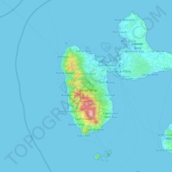
Name: Guadeloupe topographic map, elevation, terrain.

Location: Guadeloupe, France (15.83198 -61.80976 16.51448 -61.00130)

Average elevation: 37 m

Minimum elevation: -1 m

Maximum elevation: 1,442 m

Other topographic maps

Click on a map to view its topography, its elevation and its terrain.

Metz

France > Grand Est > Moselle

Average elevation: 196 m

34240

France > Occitania > Hérault > Combes

Average elevation: 402 m

Bridiers

France > Nouvelle-Aquitaine > Creuse > La Souterraine

Average elevation: 399 m

Briançon

France > Provence-Alpes-Côte d'Azur > Hautes-Alpes

Briançon (French: [bʁijɑ̃sɔ̃] , Occitan: [bɾjanˈsun]) is the sole subprefecture of the Hautes-Alpes department in the Provence-Alpes-Côte d'Azur region in Southeastern France. It is the highest city in France at an altitude of 1,326 metres (4,350 feet), based on the national definition as a community…

Average elevation: 1,614 m

Rans

France > Bourgogne – Franche-Comté > Jura

Average elevation: 239 m

19250

France > Nouvelle-Aquitaine > Corrèze > Ambrugeat > Le Montbazet

Average elevation: 681 m

Gap

France > Provence-Alpes-Côte d'Azur > Hautes-Alpes

The cover of morainic debris is omnipresent in the Sillon de Gap but is not the only vestige of the Quaternary glaciation. There is also the typical topography of glacial valleys. The location of the town of Gap corresponds to an Ombilic glaciaire, where large quantities of clay were deposited. Upstream lies…

Average elevation: 1,146 m

Martinique

France

Average elevation: 22 m

French Polynesia

France

Average elevation: 0 m

French Guiana

France

French Guiana has an equatorial climate predominant. Located within six degrees of the Equator and rising only to modest elevations, French Guiana is hot and oppressively humid all year round. During most of the year, rainfall across the country is heavy due to the presence of the Intertropical Convergence…

Average elevation: 103 m

La Chapelle-Janson

France > Brittany > Ille-et-Vilaine

Average elevation: 140 m

Poitou-Charentes

France

Average elevation: 106 m

Nouvelle-Aquitaine

France

The region Nouvelle-Aquitaine essentially has a more or less altered oceanic climate. We distinguish the Aquitaine oceanic climate, which concerns most of the territory (Charentes to Landes), the Paris oceanic climate (Poitou), Limousin oceanic climate, tinged with semi-continental influences (Limousin) and…

Average elevation: 258 m

Grande Terre

France

The island is located roughly 1,300 kilometres (810 mi; 700 nmi) east of Australia. Grande Terre is oriented northwest-to-southeast; its area is 16,372 square kilometres (6,321 square miles). It is nearly 400 kilometres (250 miles) in length and 50–70 km (30–40 mi) wide in most places. A mountain range…

Average elevation: 44 m

Herm

France > Nouvelle-Aquitaine > Landes

Average elevation: 57 m

Centre-Val de Loire

France

Average elevation: 154 m

Saint Martin (France)

France

Average elevation: 2 m

Mangareva

France > French Polynesia

Average elevation: 16 m

Society Islands

France > French Polynesia

Average elevation: 1 m

Marquesas Islands

France > French Polynesia

Although Polynesia tends to be associated with images of lush tropical vegetation, and the Marquesas lie within the tropics, they are remarkably dry. That is because they constitute the first major break for the prevailing easterly winds that arise from the (atmospherically) dry Humboldt Current. This subjects…

Average elevation: 3 m

Sentheim

France > Grand Est > Haut-Rhin

Average elevation: 378 m

Tuamotu

France > French Polynesia > Hao

Average elevation: 0 m

Rennes-le-Château

France > Occitania > Aude

Average elevation: 407 m

Wallis and Futuna

France

Average elevation: 0 m

Allanche

France > Auvergne-Rhône-Alpes > Cantal

Average elevation: 1,117 m

Saint-Genis-Pouilly

France > Auvergne-Rhône-Alpes > Ain

Saint-Genis-Pouilly is composed of two market towns (Saint-Genis and Pouilly) and two hamlets (Pregnin and Flies). The two market towns have both continued to expand and now practically merge into one, however the two hamlets still remain separate from each other and from the two towns. The elevation of the…

Average elevation: 477 m

Riscle

France > Occitania > Gers

Average elevation: 128 m

Château-Verdun

France > Occitania > Ariège

Average elevation: 709 m

Tarascon-sur-Ariège

France > Occitania > Ariège

Average elevation: 683 m

Manthelon

France > Normandy > Eure > Mesnils-sur-Iton

Average elevation: 153 m

Montségur

France > Occitania > Ariège

Average elevation: 1,260 m

Caussou

France > Occitania > Ariège

Average elevation: 1,242 m

Carnac

France > Brittany > Morbihan

Average elevation: 12 m

Lavelanet

France > Occitania > Ariège

Average elevation: 587 m

La Bresse

France > Grand Est > Vosges

Average elevation: 855 m

Bray

France > Normandy > Eure

Average elevation: 150 m

Languedoc-Roussillon

France

Average elevation: 384 m

Gâtine

France > Pays de la Loire > Vendée > Sainte-Foy

Average elevation: 29 m

Réunion

France > Réunion

Already at the time of the India Route or Route des Indes, Réunion was a French possession located between Cape Town and the Indian trading posts, although far from the Mozambique Channel. Île de Bourbon (its name under the Ancien Régime) was not, however, the preferred position for trade and military.…

Average elevation: 532 m

Alsace

France

Average elevation: 414 m

Saint Martin (France)

France

Average elevation: 15 m

Cernay-la-Ville

France > Ile-de-France > Yvelines

Average elevation: 164 m