
Turkey topographic map
Interactive map
Click on the map to display elevation.
Turkey
Turkey's topography is a diverse tapestry of mountains, plateaus, and coastal plains that create a strikingly varied landscape. The country is predominantly characterized by the Anatolian Plateau, a semi-arid highland that stretches across central Turkey, with elevations ranging from 700 to 2,000 meters. This plateau is flanked by the Pontic Mountains to the north and the Taurus Mountains to the south, both of which run parallel to the respective coastlines. In the east, the terrain becomes more rugged and elevated, culminating in Mount Ararat, Turkey's highest peak at 5,137 meters. Coastal regions, such as the Aegean and Mediterranean shores, feature narrow plains that give way to rolling hills and steep mountains, while the Black Sea coast is lined with dense forests and receives the highest precipitation in the country. This complex terrain not only shapes Turkey's diverse climates and ecosystems but also influences human activities, from agriculture in the fertile basins to tourism in the picturesque valleys and mountains.
About this map
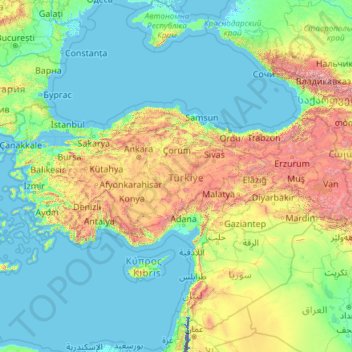
Name: Turkey topographic map, elevation, terrain.
Location: Turkey (35.80590 25.56563 42.29700 44.81766)
Average elevation: 498 m
Minimum elevation: -415 m
Maximum elevation: 4,903 m
Other topographic maps
Click on a map to view its topography, its elevation and its terrain.
Bloemfontein
South Africa > Free State > Mangaung Metropolitan Municipality
Situated at an elevation of 1,395 m (4,577 ft) above sea level, the city is home to 256,185 (as of 2011) residents and forms part of the Mangaung Metropolitan Municipality which has a population of 747,431. It was one of the host cities for the 2010 FIFA World Cup.
Average elevation: 1,374 m
Welkom
South Africa > Free State > Lejweleputswa District Municipality
Koppie Alleen is the only hill near Welkom and therefore is aptly named for its oddity. The terrain elevation above sea level is 1435 metres. The largest water catchment is the Sand River to the south-east of Welkom in Virginia's direction. Large saline pans such as Flamingo Pan and Theronia Pan are situated…
Average elevation: 1,341 m
Monterrey
Mexico > Nuevo León > Monterrey
The city of Monterrey is 540 metres (1,770 ft) above sea level in the northeastern state of Nuevo León. Monterrey translated literally from Spanish to English is "King Mount" or "King Mountain", and folk etymology claims that this refers to the city's topography and the large mountains that surround it…
Average elevation: 753 m
Schnaitheim
Germany > Baden-Württemberg > Landkreis Heidenheim > Heidenheim an der Brenz
Average elevation: 551 m
Canberra
The area chosen for the capital had been inhabited by Aboriginal Australians for up to 21,000 years, by groups including the Ngunnawal and Ngambri. European settlement commenced in the first half of the 19th century, as evidenced by surviving landmarks such as St John's Anglican Church and Blundells Cottage.…
Average elevation: 638 m
Calulo
Calulo [kɐˈlulu] is a town, with a population of 44,000 (2014), and a commune in the municipality of Libolo, province of Cuanza Sul, Angola and the seat of the municipality. The town stands at an altitude of 990 m (3,250 ft) above sea level.
Average elevation: 981 m
Derwent
United Kingdom > England > Derbyshire > High Peak > Bamford > Yorkshire Bridge
Average elevation: 293 m
Sawfar
Lebanon > Mount Lebanon Governorate
Ru’ Aysat Sawfar or Sawfar (Arabic: رويسات صوفر or صوفر, French: Rue’ Aysat Sawfar), Sawfar, Saoufar or Sofar) is a village in the Aley District of the Mount Lebanon Governorate in Lebanon. Perched at an elevation of more than 1,433 metres (4,701 feet), Sawfar lies adjacent to the main road…
Average elevation: 1,157 m
Blackboys
United States > Connecticut > Southeastern Connecticut Planning Region > East Lyme
Average elevation: 38 m
Peshawar Cantonment
Pakistan > Khyber Pakhtunkhwa > Peshāwar District > Peshawar City Tehsil
Average elevation: 352 m
Saone
Italy > Trentino – Alto Adige/Südtirol > Provincia di Trento > Tione di Trento
Average elevation: 848 m
Mediterranean Sea
Average elevation: 0 m
Han Pijesak
Bosnia and Herzegovina > Republika Srpska
Han Pijesak is located about 70km northeast from Sarajevo, on the slopes of mountain Romanija, at an altitude of 1,100m.
Average elevation: 1,092 m
Cellarhead
United Kingdom > England > Staffordshire > Staffordshire Moorlands
Average elevation: 240 m
Amfissa
Greece > Thessaly and Central Greece > Regional Unit of Phocis > Municipal Unit of Amfissa
Average elevation: 506 m
Kakamas
South Africa > Northern Cape > ZF Mgcawu District Municipality > Kai !Garib Local Municipality
Average elevation: 667 m
Lichtenburg
South Africa > North West > Ngaka Modiri Molema District Municipality > Ditsobotla Local Municipality
Average elevation: 1,480 m
Loutropigi
Greece > Thessaly and Central Greece > Karditsa Regional Unit > Municipal Unit of Menelaida
Average elevation: 563 m
Kolašin
Montenegro > Kolašin Municipality > Kolašin
Kolašin is located on the foot of Bjelasica and Sinjajevina mountains, which offer great conditions for skiing. Because of Kolašin's altitude (954 m), the town is considered an air spa.
Average elevation: 1,133 m
Iztaccíhuatl
Mexico > Puebla > San Salvador el Verde
The name "Iztaccíhuatl" is Nahuatl for "White (like salt) woman", reflecting the four individual snow-capped peaks which depict the head, chest, knees and feet of a sleeping female when seen from east or west. Iztaccíhuatl is to the north of its twin Popocatépetl, to which it is connected by the high…
Average elevation: 4,732 m
Gaborone
Botswana > South-East District
Gaborone is situated at 24°39′29″S 25°54′44″E / 24.65806°S 25.91222°E / -24.65806; 25.91222 between Kgale and Oodi Hills, on the Notwane River in the south-eastern corner of Botswana, and 15 kilometres (9.3 mi) from the South African border The city lies at an elevation of 1,010 metres…
Average elevation: 1,032 m
Kabgayi
Rwanda > Southern Province > Muhanga District > Nyamabuye
Kabgayi lies in the middle of Rwanda's central plateau at an elevation of about 6,000 feet (1,800 m) above sea level. Located in Kamazuru Village of Gahogo Cell in Nyamabuye Sector, it is a 5 minutes’ drive from Muhanga City. The community is just south of Gitarama, the second-largest city in Rwanda, and…
Average elevation: 1,835 m
Žabljak
Montenegro > Žabljak Municipality
Žabljak is the seat of Žabljak Municipality (2011 population: 3,569). The town is in the centre of the Durmitor mountain region and with an altitude of 1,456 metres, it is the highest situated Balkan town.
Average elevation: 1,461 m
Gusinje
Montenegro > Gusinje Municipality
The town is located in the Plav-Gusinje area, part of the upper Lim valley in the Accursed Mountains range at an elevation of 1,014 m. Zla Kolata, the highest mountain in Montenegro about 10 km south of Gusinje in the Prokletije National Park.
Average elevation: 1,295 m
The Matterhorn
United States > Connecticut > Northwest Hills Planning Region > Canaan
Average elevation: 462 m
Šavnik
Montenegro > Šavnik Municipality
Šavnik (Cyrillic: Шавник, pronounced [ʃǎv̞niːk]) is a town in Montenegro in the northern region and administrative center of the Šavnik Municipality. It is located at the confluence of three rivers - Bukovica, Bijela and Šavnik, at an altitude of 840 meters. It is the lowest lying settlement in…
Average elevation: 1,021 m