
Thank you for supporting this site ❤️
Make a donation
Make a donation
Llangan topographic map
Click on the map to display elevation.
Thank you for supporting this site ❤️
Make a donation
Make a donation
About this map
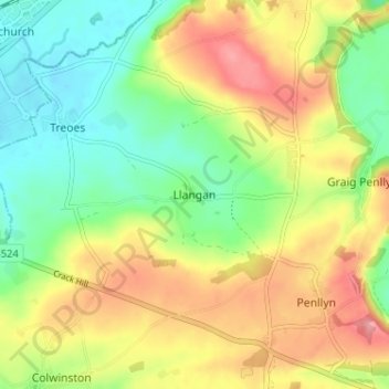
Name: Llangan topographic map, elevation, terrain.
Location: Llangan, Vale of Glamorgan, Wales, CF35 5DW, United Kingdom (51.46753 -3.52148 51.50753 -3.48148)
Average elevation: 62 m
Minimum elevation: 15 m
Maximum elevation: 121 m
Thank you for supporting this site ❤️
Make a donation
Make a donation
Other topographic maps
Click on a map to view its topography, its elevation and its terrain.
Thank you for supporting this site ❤️
Make a donation
Make a donation
Thank you for supporting this site ❤️
Make a donation
Make a donation
Cosmeston Lakes Country Park
United Kingdom > Wales > Vale of Glamorgan > Penarth
Average elevation: 26 m
Thank you for supporting this site ❤️
Make a donation
Make a donation
Thank you for supporting this site ❤️
Make a donation
Make a donation