
Make a donation
Prosto topographic map
Click on the map to display elevation.
Make a donation
About this map
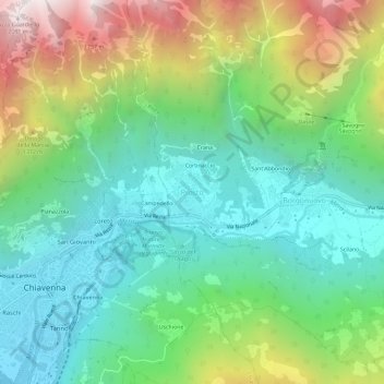
Name: Prosto topographic map, elevation, terrain.
Average elevation: 865 m
Minimum elevation: 284 m
Maximum elevation: 2,093 m
Make a donation
Other topographic maps
Click on a map to view its topography, its elevation and its terrain.
Livigno
Only three roads lead to the town. Two link to Switzerland, one through the Forcola di Livigno, elevation 2,315 m (7,595 ft) and open in summer only, and the second through the Munt la Schera Tunnel. The third road connects to other parts of Italy through the Foscagno Pass, elevation 2,291 m (7,516 ft).
Average elevation: 2,388 m
Make a donation
Bormio
For the World Cup race in December 2017, the Stelvio started at an elevation of 2,255 m (7,398 ft), with a vertical drop of 1,010 m (3,314 ft) and course length of 3.27 km (2.03 mi). The winning time of Italian Dominik Paris was just under two minutes, yielding an average speed of 100.66 km/h (62.5 mph) and a…
Average elevation: 2,018 m
Make a donation
Make a donation
Bormio
For the World Cup race in December 2017, the Stelvio started at an elevation of 2,255 m (7,398 ft), with a vertical drop of 1,010 m (3,314 ft) and course length of 3.27 km (2.03 mi). The winning time of Italian Dominik Paris was just under two minutes, yielding an average speed of 100.66 km/h (62.5 mph) and a…
Average elevation: 2,018 m
Livigno
Only three roads lead to the town. Two link to Switzerland, one through the Forcola di Livigno, elevation 2,315 m (7,595 ft) and open in summer only, and the second through the Munt la Schera Tunnel. The third road connects to other parts of Italy through the Foscagno Pass, elevation 2,291 m (7,516 ft).
Average elevation: 2,388 m
Make a donation
Bormio
For the World Cup race in December 2017, the Stelvio started at an elevation of 2,255 m (7,398 ft), with a vertical drop of 1,010 m (3,314 ft) and course length of 3.27 km (2.03 mi). The winning time of Italian Dominik Paris was just under two minutes, yielding an average speed of 100.66 km/h (62.5 mph) and a…
Average elevation: 2,018 m
Make a donation