
Make a donation
Bormio topographic map
Click on the map to display elevation.
Make a donation
Bormio
For the World Cup race in December 2017, the Stelvio started at an elevation of 2,255 m (7,398 ft), with a vertical drop of 1,010 m (3,314 ft) and course length of 3.27 km (2.03 mi). The winning time of Italian Dominik Paris was just under two minutes, yielding an average speed of 100.66 km/h (62.5 mph) and a vertical descent rate of over 8.6 metres (28 ft) per second.
Make a donation
About this map
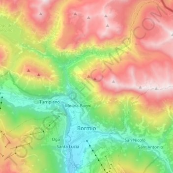
Name: Bormio topographic map, elevation, terrain.
Average elevation: 2,018 m
Minimum elevation: 1,149 m
Maximum elevation: 3,080 m
Make a donation
Other topographic maps
Click on a map to view its topography, its elevation and its terrain.
Make a donation
Make a donation
Make a donation
Make a donation
Trepalle
Italy > Lombardy > Sondrio > Livigno
Trepalle is a village (the highest in Italy) in the Italian Alps, a frazione of Livigno, Lombardy. It is sometimes considered to be the village located at the highest altitude in Europe with its church located at an altitude of 2,069 m, and the village stretching up to the Passo d'Eira at 2,209 m. However,…
Average elevation: 2,236 m
Make a donation
Trepalle
Italy > Lombardy > Sondrio > Livigno
Trepalle is a village (the highest in Italy) in the Italian Alps, a frazione of Livigno, Lombardy. It is sometimes considered to be the village located at the highest altitude in Europe and is the highest in the European Union with its church located at the Passo d'Eira at 2,209 m (7,247 ft). However, Kurush…
Average elevation: 2,236 m