
Make a donation
Livigno topographic map
Click on the map to display elevation.
Make a donation
Livigno
Only three roads lead to the town. Two link to Switzerland, one through the Forcola di Livigno, elevation 2,315 m (7,595 ft) and open in summer only, and the second through the Munt la Schera Tunnel. The third road connects to other parts of Italy through the Foscagno Pass, elevation 2,291 m (7,516 ft).
Make a donation
About this map
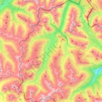
Name: Livigno topographic map, elevation, terrain.
Average elevation: 2,388 m
Minimum elevation: 1,412 m
Maximum elevation: 3,255 m
Make a donation
Other topographic maps
Click on a map to view its topography, its elevation and its terrain.
Make a donation
Make a donation
Make a donation
Make a donation
Trepalle
Italy > Lombardy > Sondrio > Livigno
Trepalle is a village (the highest in Italy) in the Italian Alps, a frazione of Livigno, Lombardy. It is sometimes considered to be the village located at the highest altitude in Europe with its church located at an altitude of 2,069 m, and the village stretching up to the Passo d'Eira at 2,209 m. However,…
Average elevation: 2,236 m
Make a donation
Trepalle
Italy > Lombardy > Sondrio > Livigno
Trepalle is a village (the highest in Italy) in the Italian Alps, a frazione of Livigno, Lombardy. It is sometimes considered to be the village located at the highest altitude in Europe and is the highest in the European Union with its church located at the Passo d'Eira at 2,209 m (7,247 ft). However, Kurush…
Average elevation: 2,236 m