
Angamarca topographic map
Interactive map
Click on the map to display elevation.
About this map
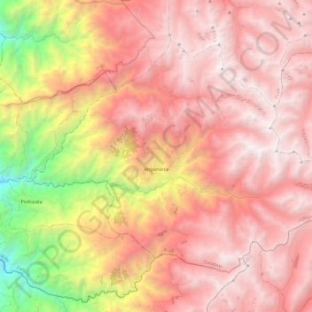
Name: Angamarca topographic map, elevation, terrain.
Location: Angamarca, Pujilí, Cotopaxi, Ecuador (-1.19723 -79.02642 -1.02061 -78.78955)
Average elevation: 3,412 m
Minimum elevation: 1,456 m
Maximum elevation: 4,550 m
Other topographic maps
Click on a map to view its topography, its elevation and its terrain.
La Victoria
La Victoria, Pujilí, Cotopaxi, 050455, Ecuador
Average elevation: 3,100 m
Tingo La Esperanza
Ecuador > Cotopaxi > Pujilí > Tingo
Tingo La Esperanza, Tingo, Pujilí, Cotopaxi, Ecuador
Average elevation: 1,754 m
Cuturivi Chico
Ecuador > Cotopaxi > Pujilí > Pujilí
Cuturivi Chico, Pujilí, Cotopaxi, 050404, Ecuador
Average elevation: 3,426 m
Tigua Centro
Ecuador > Cotopaxi > Pujilí > Guanguaje > Tigua Centro
Tigua Centro, Guanguaje, Pujilí, Cotopaxi, Ecuador
Average elevation: 3,590 m
Río Guangaje
Ecuador > Cotopaxi > Pujilí > Guanguaje
Río Guangaje, Guanguaje, Isinlivi, Pujilí, Cotopaxi, Ecuador
Average elevation: 3,318 m