
La Victoria topographic map
Interactive map
Click on the map to display elevation.
About this map
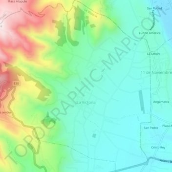
Name: La Victoria topographic map, elevation, terrain.
Location: La Victoria, Pujilí, Cotopaxi, 050455, Ecuador (-0.93822 -78.72648 -0.88918 -78.67749)
Average elevation: 3,100 m
Minimum elevation: 2,888 m
Maximum elevation: 3,599 m
Other topographic maps
Click on a map to view its topography, its elevation and its terrain.
Tingo La Esperanza
Ecuador > Cotopaxi > Pujilí > Tingo
Tingo La Esperanza, Tingo, Pujilí, Cotopaxi, Ecuador
Average elevation: 1,754 m
Cuturivi Chico
Ecuador > Cotopaxi > Pujilí > Pujilí
Cuturivi Chico, Pujilí, Cotopaxi, 050404, Ecuador
Average elevation: 3,426 m
Tigua Centro
Ecuador > Cotopaxi > Pujilí > Guanguaje > Tigua Centro
Tigua Centro, Guanguaje, Pujilí, Cotopaxi, Ecuador
Average elevation: 3,590 m
Río Guangaje
Ecuador > Cotopaxi > Pujilí > Guanguaje
Río Guangaje, Guanguaje, Isinlivi, Pujilí, Cotopaxi, Ecuador
Average elevation: 3,318 m