
Río Guangaje topographic map
Interactive map
Click on the map to display elevation.
About this map
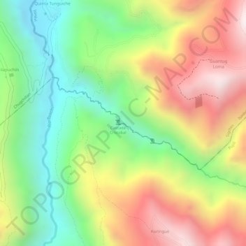
Name: Río Guangaje topographic map, elevation, terrain.
Location: Río Guangaje, Guanguaje, Isinlivi, Pujilí, Cotopaxi, Ecuador (-0.84259 -78.87172 -0.83243 -78.85557)
Average elevation: 3,318 m
Minimum elevation: 2,976 m
Maximum elevation: 3,690 m
Other topographic maps
Click on a map to view its topography, its elevation and its terrain.
Tigua Centro
Ecuador > Cotopaxi > Pujilí > Guanguaje > Tigua Centro
Tigua Centro, Guanguaje, Pujilí, Cotopaxi, Ecuador
Average elevation: 3,590 m