
Make a donation
Festiona topographic map
Click on the map to display elevation.
Make a donation
About this map
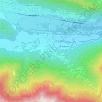
Name: Festiona topographic map, elevation, terrain.
Location: Festiona, Demonte, Cuneo, Piedmont, Italy (44.27990 7.32532 44.31990 7.36532)
Average elevation: 963 m
Minimum elevation: 673 m
Maximum elevation: 1,747 m
Make a donation
Other topographic maps
Click on a map to view its topography, its elevation and its terrain.
Make a donation
Make a donation
Make a donation
Make a donation
Make a donation
Make a donation
Make a donation
Make a donation
Make a donation
Make a donation
Make a donation
Make a donation
Make a donation
Make a donation
Peveragno
The town has an average altitude above sea level of 570 meters. At the foot of Mount Bisalta, whose name derives from the fact that it consists of two peaks close to each other but well distinguished, the highest one is 2404 m above sea level. With its main villages, S. Margherita, S. Lorenzo, S. Giovenale,…
Average elevation: 860 m
Make a donation
Make a donation
Make a donation
Make a donation
Make a donation
Make a donation
Make a donation
Chiusa di Pesio
Chiusa di Pesio is located at the beginning of the Pesio Valley (its altitude ranges from 575 metres of the main town up to over 2,600 metres of the highest peaks). The main hamlets are San Bartolomeo and Vigna, located in the highest part of the valley, and Combe, Santa Maria Rocca and Abrau which are located…
Average elevation: 1,147 m
Make a donation
Make a donation
Make a donation
Make a donation