
Make a donation
Peveragno topographic map
Click on the map to display elevation.
Make a donation
Peveragno
The town has an average altitude above sea level of 570 meters. At the foot of Mount Bisalta, whose name derives from the fact that it consists of two peaks close to each other but well distinguished, the highest one is 2404 m above sea level. With its main villages, S. Margherita, S. Lorenzo, S. Giovenale, Madonna dei Boschi, Montefallonio, Pradeboni (at an altitude of 950 m above sea level), has more than 5000 inhabitants. The town covers a large valley facing north-east and is protected in the north and west side from the S.Giorgio hill and the foothills of Moncalvino, whereas in the east side is open to Chiusa Pesio and the plain.
Make a donation
About this map
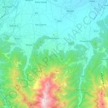
Name: Peveragno topographic map, elevation, terrain.
Location: Peveragno, Cuneo, Piedmont, 12016, Italy (44.24018 7.57699 44.37883 7.65988)
Average elevation: 860 m
Minimum elevation: 456 m
Maximum elevation: 2,387 m
Make a donation
Other topographic maps
Click on a map to view its topography, its elevation and its terrain.
Monviso
Italy > Piedmont > Cuneo > Pontechianale
Monte Viso is the location of a neolithic jadeite quarry, at an elevation of 2000 to 2400 metres. Its productivity peaked around 5000 BC. The jadeite was used to make cult axes, which are found all over western Europe. One such ceremonial axe head was found as far away as a small hill called Tristia in Western…
Average elevation: 2,985 m
Croce di Envie - Cima Bracco
Italy > Piedmont > Cuneo > Sanfront
The Monte Bracco (though the name is sometimes shortened to Mombracco) is a mountain in the Cottian Alps with an elevation of 1,307 meters above sea level. It is located between the Valle Po, the Valle Infernotto [it], and the Cuneo plain.
Average elevation: 947 m
Make a donation
Monviso
Italy > Piedmont > Cuneo > Pontechianale
Monte Viso is the location of a Neolithic jadeite quarry, at an elevation of 2,000 to 2,400 metres. Its productivity peaked around 5000 BC. The jadeite was used to make cult axes, which are found all over western Europe. One such ceremonial axe head was found as far away as a small hill called Tristia in…
Average elevation: 2,985 m
Make a donation
Monviso
Italy > Piedmont > Cuneo > Pontechianale
Monte Viso is the location of a neolithic jadeite quarry, at an elevation of 2,000 to 2,400 metres. Its productivity peaked around 5000 BC. The jadeite was used to make cult axes, which are found all over western Europe. One such ceremonial axe head was found as far away as a small hill called Tristia in…
Average elevation: 2,985 m
Make a donation
Make a donation
Make a donation
Make a donation
Make a donation
Make a donation
Make a donation
Make a donation
Giardino Famiglia Allemandi
Italy > Piedmont > Cuneo > Villar San Costanzo > Pramallé
Average elevation: 654 m
Make a donation