
Thank you for supporting this site ❤️
Make a donation
Make a donation
Belsele topographic map
Click on the map to display elevation.
Thank you for supporting this site ❤️
Make a donation
Make a donation
About this map
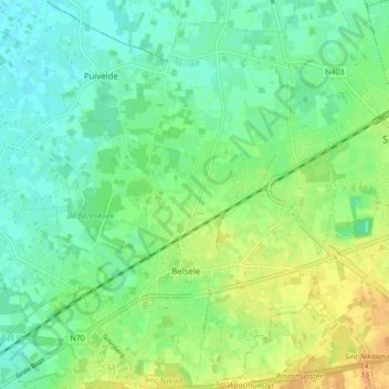
Name: Belsele topographic map, elevation, terrain.
Location: Belsele, Sint-Niklaas, Oost-Vlaanderen, 9111, België (51.12996 4.05861 51.18395 4.12397)
Average elevation: 13 m
Minimum elevation: 1 m
Maximum elevation: 32 m
Thank you for supporting this site ❤️
Make a donation
Make a donation
Other topographic maps
Click on a map to view its topography, its elevation and its terrain.
Duizend Appels
België > Oost-Vlaanderen > Sint-Niklaas > Sint-Niklaas > Belsele
Average elevation: 13 m
Thank you for supporting this site ❤️
Make a donation
Make a donation
Thank you for supporting this site ❤️
Make a donation
Make a donation
Thank you for supporting this site ❤️
Make a donation
Make a donation
Thank you for supporting this site ❤️
Make a donation
Make a donation
Populierenwijk
België > Oost-Vlaanderen > Sint-Niklaas > Sint-Niklaas > Belsele
Average elevation: 19 m
Thank you for supporting this site ❤️
Make a donation
Make a donation