
Guanajuato topographic map
Interactive map
Click on the map to display elevation.
Guanajuato
Guanajuato is in the center of Mexico, northwest of Mexico City, bordering Zacatecas, San Luis Potosí, Michoacán, Querétaro, and Jalisco. It is the 20th-largest of Mexico's states, with an area of 30,589 km². It has an average altitude of 2,015 meters (6,611 ft) above sea level, with its territory divided among three of Mexico's physical regions, the Sierra Madre Oriental, the Mexican Plateau and the Trans-Mexican Volcanic Belt. The Sierra Madre Oriental in Guanajuato consists of the Sierra Gorda and the Sierra del Azafrán in the northeast. The Mexican Plateau extends through the center of the state. It is subdivided into various regions parted by low-lying mountain chains such as the Sierra de la Cuatralba and the Sierra de Cubo. The Trans Mexican Volcanic Belt crosses the state in the south and includes the Bajío area, the Altos de Jalisco and the valleys area in the far south. The state is crossed by several mountain ranges with mountains between 2,300 and 3,000 meters high. Mountain ranges average 2,305 meters and flat areas lie at around 1,725 meters above mean sea level. Other important mountain ranges include the Sierra Gorda to the north, the Sierra de Guanajuato in the southeast, the Comanja in the northwest and the Codorniz in the east.
About this map
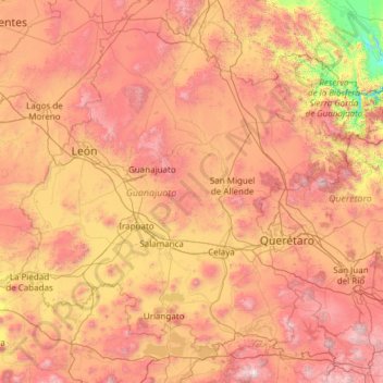
Name: Guanajuato topographic map, elevation, terrain.
Location: Guanajuato, Mexico (19.91275 -102.09728 21.83942 -99.67130)
Average elevation: 2,005 m
Minimum elevation: 873 m
Maximum elevation: 3,508 m
Other topographic maps
Click on a map to view its topography, its elevation and its terrain.
Jilotlan de los Dolores
Mexico > Jalisco > Jilotlán de los Dolores > Jilotlan de los Dolores
Average elevation: 862 m
San Miguel el Alto
Mexico > Jalisco > San Miguel el Alto > San Miguel el Alto
Average elevation: 1,887 m
Hermosillo
Mexico > Sonora > Hermosillo > Hermosillo
The Cerro de la Campana mountain is one of the symbols of Hermosillo. Its summit is 350 metres (1,150 ft) above the valley floor and contains a lookout called El Caracol, which was inaugurated in 1909. There are two theories as to the origin of the mountain's name. One states that it is from a peculiar…
Average elevation: 248 m
San Lorenzo Tlalmimilolpan
Mexico > State of Mexico > San Lorenzo Tlalmimilolpan
Average elevation: 2,274 m
Tamazula de Gordiano
Mexico > Jalisco > Tamazula de Gordiano > Tamazula de Gordiano
Average elevation: 1,222 m
San Sebastián del Sur
Mexico > Jalisco > Gómez Farías > San Sebastián del Sur
Average elevation: 1,623 m
Paseos del Valle
Mexico > Jalisco > Tlajomulco de Zuñiga > Santa Cruz del Valle > Paseos del Valle
Average elevation: 1,532 m
Atotonilco El Alto
Mexico > Jalisco > Atotonilco el Alto > Atotonilco El Alto
Average elevation: 1,712 m
San Diego de Alejandría
Mexico > Jalisco > San Diego de Alejandría > San Diego de Alejandría
Average elevation: 1,882 m
Unión de San Antonio
Mexico > Jalisco > Unión de San Antonio > Unión de San Antonio
Average elevation: 1,900 m
Delegación de la Pila
Mexico > San Luis Potosi > Municipio de San Luis Potosí > Delegación de la Pila
Average elevation: 1,868 m