
Zagreb topographic map
Interactive map
Click on the map to display elevation.
About this map
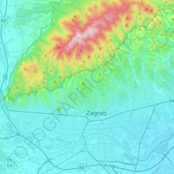
Name: Zagreb topographic map, elevation, terrain.
Location: Zagreb, City of Zagreb, Croatia (45.74600 15.82171 45.93930 16.10701)
Average elevation: 249 m
Minimum elevation: 100 m
Maximum elevation: 1,022 m
Zagreb (/ˈzɑːɡrɛb, ˈzæɡrɛb, zɑːˈɡrɛb/; Croatian pronunciation: (listen)) is the capital and the largest city of Croatia. It is located in the northwest of the country, along the Sava river, at the southern slopes of the Medvednica mountain. Zagreb lies at an elevation of approximately 122 m (400 ft) above sea level. The estimated population of the city in 2018 was 820,678. The population of the Zagreb urban agglomeration is about 1.2 million, approximately a quarter of the total population of Croatia.
Other topographic maps
Click on a map to view its topography, its elevation and its terrain.
Brezovac
Brezovac, Općina Rakovica, Karlovac County, 47254, Croatia
Average elevation: 341 m
Pavković Selo
Pavković Selo, Općina Krnjak, Karlovac County, 47242, Croatia
Average elevation: 164 m
Čiovo
Croatia > Split-Dalmatia County > Žedno
Čiovo, Žedno, Grad Trogir, Split-Dalmatia County, Croatia
Average elevation: 46 m
Općina Čavle
Croatia > Primorje-Gorski Kotar County
Općina Čavle, Primorje-Gorski Kotar County, 51219, Croatia
Average elevation: 800 m
Osijek
Croatia > Osijek-Baranja County
Osijek, Grad Osijek, Osijek-Baranja County, Croatia
Average elevation: 87 m
Grad Sisak
Croatia > Sisak-Moslavina County > Grad Sisak
Grad Sisak, Sisak, Sisak-Moslavina County, Croatia
Average elevation: 132 m
Banja
Croatia > Split-Dalmatia County > Banja
Banja, Grad Vrgorac, Split-Dalmatia County, 21276, Croatia
Average elevation: 273 m
Mali Lošinj
Mali Lošinj, Primorje-Gorski Kotar County, 51553, Croatia
Average elevation: 15 m
Trešnjevka - sjever
Trešnjevka - sjever, Zagreb, City of Zagreb, 10110, Croatia
Average elevation: 129 m