Zagreb County topographic map
Interactive map
Click on the map to display elevation.
About this map
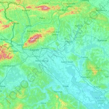
Name: Zagreb County topographic map, elevation, terrain.
Location: Zagreb County, Croatia (45.46714 15.32788 46.06950 16.71406)
Average elevation: 176 m
Minimum elevation: 89 m
Maximum elevation: 1,016 m
Other topographic maps
Click on a map to view its topography, its elevation and its terrain.
City of Zagreb
Zagreb (/ˈzɑːɡrɛb/ ZAH-greb Croatian: [zǎːɡreb] ) is the capital and largest city of Croatia. It is in the north of the country, along the Sava river, at the southern slopes of the Medvednica mountain. Zagreb stands near the international border between Croatia and Slovenia at an elevation of…
Average elevation: 182 m
Osijek
Croatia > Osijek-Baranja County
Osijek (Croatian pronunciation: [ôsijeːk] ) is the fourth-largest city in Croatia, with a population of 96,848 in 2021. It is the largest city and the economic and cultural centre of the eastern Croatian region of Slavonia, as well as the administrative centre of Osijek-Baranja County. Osijek is on the right…
Average elevation: 87 m
Zagreb
Zagreb (/ˈzɑːɡrɛb, ˈzæɡrɛb, zɑːˈɡrɛb/; Croatian pronunciation: (listen)) is the capital and the largest city of Croatia. It is located in the northwest of the country, along the Sava river, at the southern slopes of the Medvednica mountain. Zagreb lies at an elevation of approximately 122 m (400…
Average elevation: 249 m