Geolocate

City of Zagreb topographic map

Interactive map

Click on the map to display elevation.

City of Zagreb

Zagreb (/ˈzɑːɡrɛb/ ZAH-greb Croatian: [zǎːɡreb] ) is the capital and largest city of Croatia. It is in the north of the country, along the Sava river, at the southern slopes of the Medvednica mountain. Zagreb stands near the international border between Croatia and Slovenia at an elevation of approximately 158 m (518 ft) above sea level. The population of the Zagreb urban agglomeration is 1,271,150, between a quarter and a third of the total population of Croatia, while at the 2021 census, the city itself had a population of 878,131.

Wikipedia (CC-BY-SA 3.0)

About this map

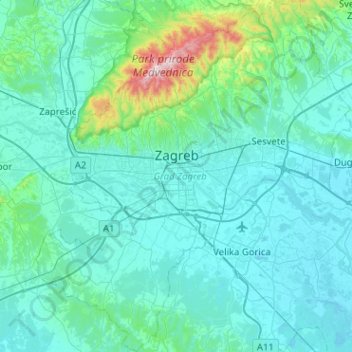
Name: City of Zagreb topographic map, elevation, terrain.

Location: City of Zagreb, Croatia (45.61395 15.77321 45.96915 16.23955)

Average elevation: 182 m

Minimum elevation: 96 m

Maximum elevation: 1,025 m

Other topographic maps

Click on a map to view its topography, its elevation and its terrain.

Zlatar

Croatia > Krapina-Zagorje County

Average elevation: 202 m

Brezovac

Croatia > Karlovac County

Average elevation: 341 m

Pavković Selo

Croatia > Karlovac County

Average elevation: 164 m

Dubrovnik-Neretva County

Croatia

Average elevation: 174 m

Split-Dalmatia County

Croatia

Average elevation: 255 m

Zagreb County

Croatia

Average elevation: 176 m

Karlovac County

Croatia

Average elevation: 396 m

Čiovo

Croatia > Split-Dalmatia County > Žedno

Average elevation: 46 m

Pula

Croatia > Pula

Average elevation: 38 m

Osijek

Croatia > Osijek-Baranja County

Osijek (Croatian pronunciation: [ôsijeːk] ) is the fourth-largest city in Croatia, with a population of 96,848 in 2021. It is the largest city and the economic and cultural centre of the eastern Croatian region of Slavonia, as well as the administrative centre of Osijek-Baranja County. Osijek is on the right…

Average elevation: 87 m

Grad Sisak

Croatia > Sisak-Moslavina County > Grad Sisak

Average elevation: 132 m

Zagreb

Croatia

Zagreb (/ˈzɑːɡrɛb, ˈzæɡrɛb, zɑːˈɡrɛb/; Croatian pronunciation: (listen)) is the capital and the largest city of Croatia. It is located in the northwest of the country, along the Sava river, at the southern slopes of the Medvednica mountain. Zagreb lies at an elevation of approximately 122 m (400…

Average elevation: 249 m

Istra

Croatia

Average elevation: 183 m

Banja

Croatia > Split-Dalmatia County > Banja

Average elevation: 273 m

Mali Lošinj

Croatia > Mali Lošinj

Average elevation: 15 m

Mljet

Croatia

Average elevation: 45 m

Split

Croatia > Split

Average elevation: 201 m

Gospić

Croatia > Gospić

Average elevation: 565 m

Istria County

Croatia

Average elevation: 129 m

Durovići

Croatia > Durovići

Average elevation: 104 m

Lika-Senj County

Croatia

Average elevation: 457 m

Trešnjevka - sjever

Croatia > Zagreb

Average elevation: 129 m