
Make a donation
Encinitas topographic map
Click on the map to display elevation.
Make a donation
Encinitas
Encinitas lies on a rugged coastal terrace. The city is bisected by a low-lying coastal ridge that separates New and Old Encinitas. In the north of the city, the coast rises in elevation and the land is raised up in the form of many coastal bluffs, which are subject to collapsing on the narrow beach. The city is bounded by Batiquitos Lagoon to the north and San Elijo Lagoon to the south.
Make a donation
About this map
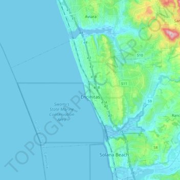
Name: Encinitas topographic map, elevation, terrain.
Location: Encinitas, California, United States (32.99599 -117.36829 33.08897 -117.19570)
Average elevation: 32 m
Minimum elevation: -1 m
Maximum elevation: 317 m
Make a donation
Other topographic maps
Click on a map to view its topography, its elevation and its terrain.
Mount Shasta
United States > California > Siskiyou County
Mount Shasta (/ˈʃæstə/ SHASS-tə; Shasta: Waka-nunee-Tuki-wuki; Karuk: Úytaahkoo) is a potentially active stratovolcano at the southern end of the Cascade Range in Siskiyou County, California. At an elevation of 14,179 ft (4,322 m), it is the second-highest peak in the Cascades and the fifth-highest in…
Average elevation: 3,717 m
Make a donation
Elk Creek
United States > California > Glenn County > Elk Creek
Elk Creek is a census-designated place in Glenn County, California. It is located 19 miles (31 km) northwest of Willows, at an elevation of 745 feet (227 m).
Average elevation: 258 m