
Hamilton County topographic map
Interactive map
Click on the map to display elevation.
About this map
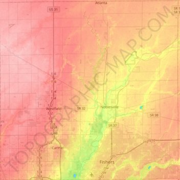
Name: Hamilton County topographic map, elevation, terrain.
Location: Hamilton County, Indiana, United States (39.92604 -86.24274 40.21894 -85.86209)
Average elevation: 261 m
Minimum elevation: 190 m
Maximum elevation: 296 m
Other topographic maps
Click on a map to view its topography, its elevation and its terrain.
Indianapolis
United States > Indiana > Indianapolis
Indianapolis, Marion County, Indiana, 46204, United States
Average elevation: 241 m
Bloomington
United States > Indiana > Monroe County
Bloomington, Monroe County, Indiana, United States
Average elevation: 241 m
Lafayette
United States > Indiana > Tippecanoe County
Lafayette, Tippecanoe County, Indiana, United States
Average elevation: 193 m
Noblesville
United States > Indiana > Hamilton County
Noblesville, Hamilton County, Indiana, 46060, United States
Average elevation: 249 m
West Lafayette
United States > Indiana > Tippecanoe County
West Lafayette, Tippecanoe County, Indiana, United States
Average elevation: 192 m
South Bend
United States > Indiana > Saint Joseph County
South Bend, Saint Joseph County, Indiana, United States
Average elevation: 236 m
Fort Wayne
United States > Indiana > Allen County
Fort Wayne, Allen County, Indiana, United States
Average elevation: 246 m
North Gate
United States > Indiana > Bartholomew County
North Gate, Bartholomew County, Indiana, 47280, United States
Average elevation: 197 m
Evansville
United States > Indiana > Vanderburgh County
Evansville, Vanderburgh County, Indiana, United States
Average elevation: 122 m
Valparaiso
United States > Indiana > Porter County
Valparaiso, Porter County, Indiana, United States
Average elevation: 235 m
Tippecanoe County
Tippecanoe County, Indiana, United States
Average elevation: 211 m
Brekenridge Park
United States > Indiana > Warrick County > Boonville
Brekenridge Park, Boonville, Warrick County, Indiana, United States
Average elevation: 126 m
Eagle Creek Park
United States > Indiana > Marion County > Indianapolis
Eagle Creek Park, Indianapolis, Marion County, Indiana, 46253, United States
Average elevation: 256 m
Koontz Lake
United States > Indiana > Starke County
Koontz Lake, Starke County, Indiana, United States
Average elevation: 221 m
Princeton
United States > Indiana > Gibson County
Princeton, Gibson County, Indiana, 47670, United States
Average elevation: 149 m
Saint Joseph County
Saint Joseph County, Indiana, United States
Average elevation: 239 m
Perkins
United States > Indiana > Newton County
Perkins, Newton County, Indiana, United States
Average elevation: 211 m
Old Pekin
United States > Indiana > Washington County
Old Pekin, Washington County, Indiana, 47165, United States
Average elevation: 229 m
Nineveh
United States > Indiana > Johnson County
Nineveh, Johnson County, Indiana, United States
Average elevation: 238 m
Plymouth
United States > Indiana > Marshall County
Plymouth, Marshall County, Indiana, 46563, United States
Average elevation: 247 m
Portage
United States > Indiana > Porter County
Portage, Porter County, Indiana, United States
Average elevation: 190 m
Syracuse
United States > Indiana > Kosciusko County
Syracuse, Kosciusko County, Indiana, United States
Average elevation: 267 m
Bluffton
United States > Indiana > Wells County
Bluffton, Wells County, Indiana, 46714, United States
Average elevation: 254 m
Rock Hill
United States > Indiana > Spencer County
Rock Hill, Spencer County, Indiana, United States
Average elevation: 124 m
York
United States > Indiana > Steuben County
York, Steuben County, Indiana, United States
Average elevation: 320 m
Berlien
United States > Indiana > Steuben County
Berlien, Steuben County, Indiana, United States
Average elevation: 312 m
Montpelier
United States > Indiana > Blackford County
Montpelier, Blackford County, Indiana, 47359, United States
Average elevation: 266 m
Alvarado
United States > Indiana > Steuben County
Alvarado, Steuben County, Indiana, United States
Average elevation: 292 m
Metz
United States > Indiana > Steuben County
Metz, Steuben County, Indiana, United States
Average elevation: 297 m
Spring Grove
United States > Indiana > Wayne County
Spring Grove, Wayne County, Indiana, United States
Average elevation: 300 m
Union City
United States > Indiana > Randolph County
Union City, Randolph County, Indiana, United States
Average elevation: 333 m
Chain O'Lakes State Park
United States > Indiana > Noble County
Chain O'Lakes State Park, 9, Noble County, Indiana, United States
Average elevation: 290 m
Shirley
United States > Indiana > Hancock County
Shirley, Hancock County, Indiana, United States
Average elevation: 312 m
Knightstown
United States > Indiana > Henry County
Knightstown, Henry County, Indiana, United States
Average elevation: 285 m
Switz City
United States > Indiana > Greene County
Switz City, Greene County, Indiana, 47465, United States
Average elevation: 162 m
Springport
United States > Indiana > Henry County
Springport, Henry County, Indiana, United States
Average elevation: 319 m
Middletown
United States > Indiana > Henry County
Middletown, Henry County, Indiana, United States
Average elevation: 297 m
Cumberland
United States > Indiana > Hancock County
Cumberland, Hancock County, Indiana, United States
Average elevation: 261 m
New Palestine
United States > Indiana > Hancock County
New Palestine, Hancock County, Indiana, United States
Average elevation: 253 m
Mohawk
United States > Indiana > Hancock County
Mohawk, Hancock County, Indiana, United States
Average elevation: 265 m
Mooreland
United States > Indiana > Henry County
Mooreland, Henry County, Indiana, United States
Average elevation: 344 m
Cadiz
United States > Indiana > Henry County
Cadiz, Henry County, Indiana, United States
Average elevation: 327 m
Depauw
United States > Indiana > Harrison County
Depauw, Harrison County, Indiana, 47115, United States
Average elevation: 225 m
Sugar Grove
United States > Indiana > Harrison County
Sugar Grove, Harrison County, Indiana, United States
Average elevation: 171 m
Palmyra
United States > Indiana > Harrison County
Palmyra, Harrison County, Indiana, United States
Average elevation: 236 m