
Thank you for supporting this site ❤️
Make a donation
Make a donation
Friendsville topographic map
Click on the map to display elevation.
Thank you for supporting this site ❤️
Make a donation
Make a donation
About this map
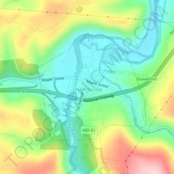
Name: Friendsville topographic map, elevation, terrain.
Location: Friendsville, Garrett County, Maryland, United States (39.65441 -79.41512 39.67096 -79.39321)
Average elevation: 528 m
Minimum elevation: 437 m
Maximum elevation: 679 m
Thank you for supporting this site ❤️
Make a donation
Make a donation
Other topographic maps
Click on a map to view its topography, its elevation and its terrain.