
Thank you for supporting this site ❤️
Make a donation
Make a donation
Ravens' Walk topographic map
Click on the map to display elevation.
Thank you for supporting this site ❤️
Make a donation
Make a donation
About this map
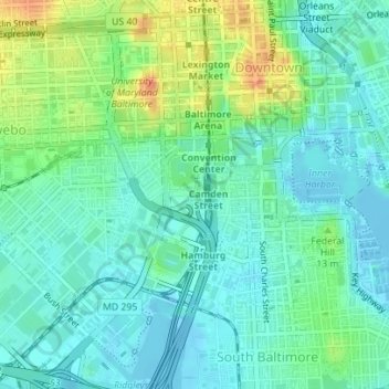
Name: Ravens' Walk topographic map, elevation, terrain.
Location: Ravens' Walk, Sowebo, Baltimore, Maryland, United States (39.28186 -76.62187 39.28283 -76.62031)
Average elevation: 15 m
Minimum elevation: -11 m
Maximum elevation: 49 m
Thank you for supporting this site ❤️
Make a donation
Make a donation
Other topographic maps
Click on a map to view its topography, its elevation and its terrain.
Thank you for supporting this site ❤️
Make a donation
Make a donation
Thank you for supporting this site ❤️
Make a donation
Make a donation
Thank you for supporting this site ❤️
Make a donation
Make a donation