
Thank you for supporting this site ❤️
Make a donation
Make a donation
Downtown topographic map
Click on the map to display elevation.
Thank you for supporting this site ❤️
Make a donation
Make a donation
About this map
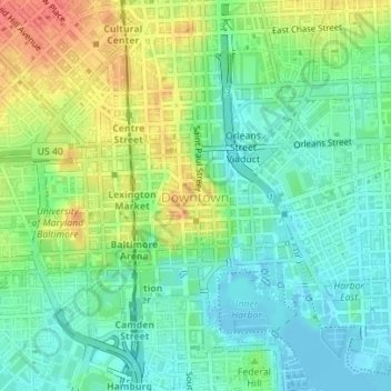
Name: Downtown topographic map, elevation, terrain.
Location: Downtown, Baltimore, Maryland, United States (39.28746 -76.62388 39.29514 -76.60473)
Average elevation: 20 m
Minimum elevation: -10 m
Maximum elevation: 53 m
Thank you for supporting this site ❤️
Make a donation
Make a donation
Other topographic maps
Click on a map to view its topography, its elevation and its terrain.